
48 min walk
Shri Swaminarayan Mandir
- Must see
- Place of worship
Language · 11 published
Nature site · Nairobi
| Monday | 06:00 – 17:30 |
|---|---|
| Tuesday | 06:00 – 17:30 |
| Wednesday | 06:00 – 17:30 |
| Thursday | 06:00 – 17:30 |
| Friday | 06:00 – 17:30 |
| Saturday | 06:00 – 17:30 |
| Sunday | 06:00 – 17:30 |
Checked 2026-08-28 · Source
Karura Forest Reserve is Nairobi's largest protected urban forest and a working water catchment managed by the Kenya Forest Service with the Friends of Karura Forest community association. The reserve lies about six kilometres north of the city centre and is split by Limuru Road into the main Karura block and the smaller Sigiria block. Visitors come for marked walking, running and cycling routes rather than a single monument. The forest's conservation story is part of the visit: Friends of Karura records the campaign led by Wangari Maathai and other citizens against land grabbing, followed by the joint management programme that began in 2009.
Checked 2026-08-28 · Source
The reserve combines a trail network with natural and historical features spread across a large area. Friends of Karura identifies a 15-metre waterfall, sacred caves used as hideouts by Mau Mau fighters, Lily Lake in a former quarry, bamboo patches, wetlands, indigenous woodland and an old chimney once used to burn withdrawn currency. Colour-coded routes cover five, ten and fifteen kilometres, while a separate northern bike trail links the main network with Sharks Gate. Picnics are limited to named sites, and dog walking follows mapped on-leash and off-leash zones. The detailed official map is more useful than trying to see every feature in one circuit.
Checked 2026-08-28 · Source
Allow two to three hours for one marked loop with time at the waterfall, caves or a picnic site. The operator's eco-tour is designed as a two-hour visit, which is a useful minimum for first-time orientation, while the marked five-, ten- and fifteen-kilometre routes make longer visits straightforward. Karura Forest is too extensive for a complete circuit of both Karura and Sigiria in a short stop. Choose the gate and route before arrival, keep enough time to retrace a wrong turn, and finish well before the gates lock. A visit focused only on a short run can be quicker, but that is a different use of the reserve.
Checked 2026-08-28 · Source
Enter early enough to complete the chosen trail in daylight. Friends of Karura currently lists entry from 06:00, last entry at 17:30 and gates locked at 19:00. Morning is the practical choice for runners, birdwatchers and anyone avoiding Nairobi's warmer middle hours. Rain changes the visit because forest paths can become wet and slippery. Current day-specific closures, maintenance diversions and event restrictions are Not recorded here and should be checked with the operator shortly before departure. Treat 17:30 as the latest arrival, not as a target, because the route still has to be completed and every visitor must leave before the gates lock.
Checked 2026-08-28 · Source
Karura Forest charges entry, and the operator directs visitors to its current fees guide rather than presenting the reserve as free public parkland. Friends of Karura states that payment is through M-Pesa via eCitizen and that parking, picnics, maps, guidebooks, bike use, tours and annual passes can carry separate charges. The current daily amount is Not recorded in this guide because the operator's live fee route should be checked at the time of the visit. Confirm the correct citizen, resident or non-resident category before paying, and do not treat an annual membership or vehicle pass as a substitute for every other charge.
Checked 2026-08-28 · Source
Choose the entrance for the activity rather than navigating only to the reserve name. Gate A on Limuru Road is the main vehicle entrance and serves the KFEET centre and forest offices; Gate C on Kiambu Road is useful for biking and designated dog routes; Gates D and E are pedestrian entrances; and Gate F serves Sigiria from Thigiri Lane. Friends of Karura lists matatus 11B, 106, 107 and 116 for the Limuru Road side, and 100, 120, 121 and 116 for Kiambu Road. Gate B is a service gate closed to the public. Download the official map before leaving reliable mobile coverage.
Checked 2026-08-28 · Source
Stay on marked routes, carry the official map and note the operator's emergency number before entering. Friends of Karura warns that mobile reception is almost absent along the Karura River between the Mau Mau caves and the waterfall, and that wet trails can be slippery. Motorbikes, loud music, campfires and fireworks are prohibited; driving is restricted to the short authorised route between Limuru Road and KFEET with a 20 kph limit. Dogs need registration and must remain on-leash except in clearly designated zones. Do not approach wildlife, enter closed areas or rely on an unverified shortcut when daylight is running out.
Checked 2026-08-28 · Source
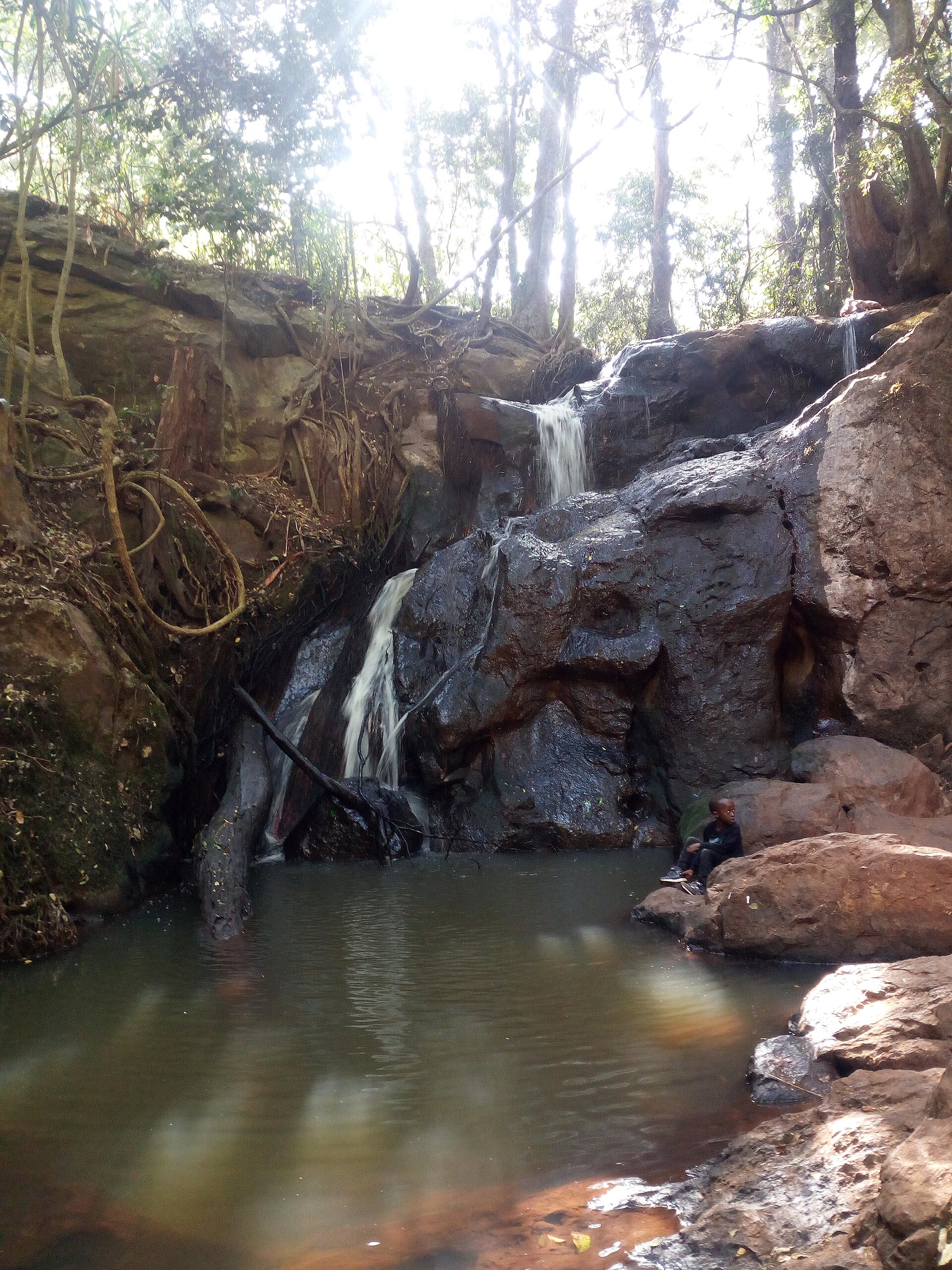
The waterfall, forest paths, bamboo, wetlands and Lily Lake provide the clearest visual subjects, but a photograph must not take a visitor off the marked trail or disturb wildlife. The licensed lead image records the Karura waterfall and is credited to Mbkimani under CC BY-SA 4.0. Friends of Karura runs photography activities, but its general visitor pages do not record a blanket policy for flash, tripods, drones or commercial filming. Those permissions are therefore Not recorded. Use a hand-held camera from public paths, keep routes clear and contact the operator in advance for equipment or work beyond ordinary personal photography.
Checked 2026-08-28 · Source
Allow two to three hours for one marked loop with a major feature such as the waterfall or caves. The official eco-tour lasts two hours, while longer marked routes can occupy much of a day.
Friends of Karura currently lists entry from 06:00, last entry at 17:30 and the gates locked at 19:00. Confirm the operator's live essential-information page before travelling.
No. The reserve charges entry and directs visitors to its current fees guide. Parking, picnics, maps, guided activities and other services can be charged separately.
Gate A is the main Limuru Road vehicle entrance, Gate C is useful for biking and dog routes, and Gate F serves Sigiria. Gates D and E are pedestrian entrances; Gate B is not open to the public.
The operator identifies a 15-metre waterfall, Mau Mau caves, Lily Lake, bamboo, wetlands and indigenous woodland. Use the official map to select a realistic route between them.
Yes, but dogs must be registered and remain on-leash except in specifically marked off-leash zones. The official map shows which routes apply.
Loading the interactive map…
The interactive map could not be loaded.


Last updated:
Source: OpenStreetMap contributors ·