Smart Self-Managed Tours

City guide · South Korea

Seoul

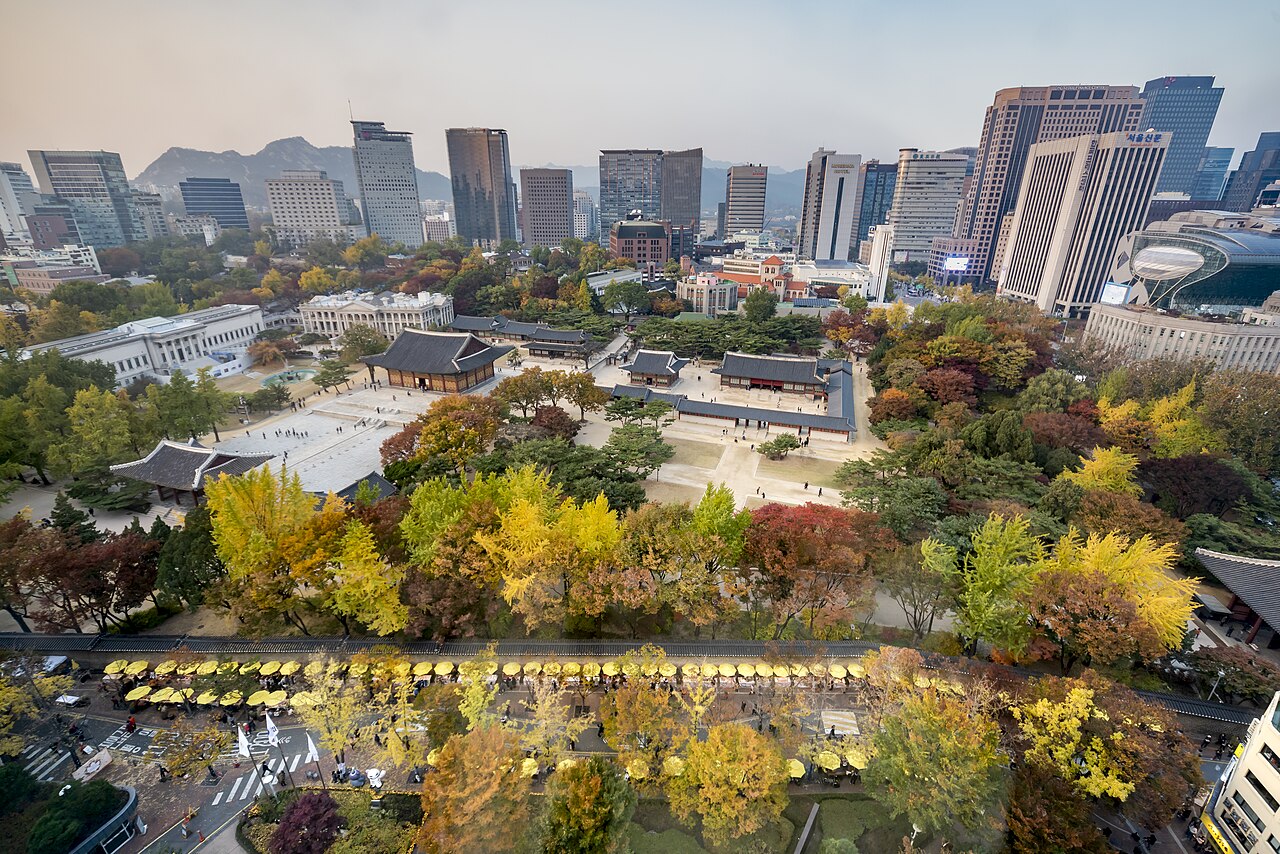
A photograph of Seoul
Photograph · 라성민 · CC BY-SA 3.0

Seoul is 605.21 km² holding 9,579,449 people at the start of 2026, inside a metropolitan area of 26,037,000 spread over 12,685 km². The Han River bisects it, and the halves are not interchangeable: Gangbuk to the north carries the Joseon capital, Gangnam to the south was built in the last fifty years. Four mountains — Bugaksan, Inwangsan, Naksan and Namsan — frame the old centre, and Gyeongbokgung, completed in 1395, sits under the first of them. Twenty-five gu and 467 administrative dong are stitched together by a metro that carried around seven million passengers a day in 2024. A visitor will use six or seven of those districts.

Practical information

Not recorded No country-level practical facts — language, currency, emergency number, plug type — are ingested yet. This section will populate once that data source is added.

Planning a visit

Suggested stay
4–5 days
Getting around
Subway, bus and T-money
  1. January: no seasonality data recorded
  2. February: seasonal closure recorded
  3. March: seasonal closure recorded
  4. April: seasonal closure recorded
  5. May: seasonal closure recorded
  6. June: no seasonality data recorded
  7. July: no seasonality data recorded
  8. August: no seasonality data recorded — this month
  9. September: seasonal closure recorded
  10. October: seasonal closure recorded
  11. November: no seasonality data recorded
  12. December: no seasonality data recorded

Top things to see

Ranked by importance — sitelinks, pageviews and heritage status, not editor preference.

  1. Changdeokgung
    02 3 hours

    Changdeokgung

    Changdeokgung was raised in 1405 as a secondary palace to Gyeongbokgung, and the garden on the slope behind it was laid out the following year.

    • Must see
    • Historic monument
  2. Jongmyo
    03 1 hr 30 min

    Jongmyo

    Jongmyo is the Confucian royal ancestral shrine of the Joseon dynasty, and it is a working ritual precinct rather than a temple or a palace.

    • Must see
    • Historic monument
  3. Namsan Seoul Tower
    04 1 hr 30 min

    Namsan Seoul Tower

    Namsan Seoul Tower is a working broadcast mast with an observation deck bolted onto it, standing on the summit of Namsan, the wooded hill that sits in the middle of central Seoul.

    • Must see
    • Historic monument
  4. Bukchon Hanok Village
    05 1 hr 30 min

    Bukchon Hanok Village

    Bukchon is a lived-in neighbourhood rather than a museum village, and every rule a visitor meets there follows from that one fact.

    • Must see
    • Historic monument
  5. Cheonggyecheon
    06 1 hr 30 min

    Cheonggyecheon

    Cheonggyecheon is an 11-kilometre stream running through the middle of Seoul, sunk a storey below street level between Cheonggye Plaza and the Hangang River.

    • Must see
    • Nature site
  6. Deoksugung
    07 1 hr 30 min

    Deoksugung

    Deoksugung is the palace of the Korean Empire, and the Royal Palaces and Tombs Center's own history of it is unusually blunt about how it became one.

    • Must see
    • Historic monument
  7. Gwangjang Market
    08 1 hr 30 min

    Gwangjang Market

    Gwangjang Market fills a block of Jongno-gu at 88 Changgyeonggung-ro, on the ground between Jongno 4-ga and Yeji-dong, and its merchants describe it as the first permanent market in Korea.

    • Must see
    • Market
  8. 09 1 hour

    • Notable
    • Art and culture venue
  9. 10 2 hours

    • Notable
    • Nightlife venue
  10. 11 1 hour

    • Notable
    • Nature site
  11. 12 1 hour

    • Notable
    • Nature site
  12. 13 2 hours

    • Notable
    • Nightlife venue
  13. 14 1 hour

    • Notable
    • Nature site
  14. 15 2 hours

    • Notable
    • Nightlife venue
  15. 16 2 hours

    • Notable
    • Nightlife venue
  16. 17 2 hours

    • Notable
    • Nightlife venue
  17. 18 1 hour

    • Notable
    • Art and culture venue
  18. 19 2 hours

    • Notable
    • Nightlife venue
  19. 20 2 hours

    • Notable
    • Nightlife venue
  20. 21 2 hours

    • Notable
    • Nightlife venue
  21. 22 2 hours

    • Notable
    • Nightlife venue
  22. 23 2 hours

    • Notable
    • Nightlife venue
  23. 24 2 hours

    • Notable
    • Nightlife venue
  24. 25 2 hours

    • Notable
    • Nightlife venue

How the city is laid out

Seoul is a river city with a mountain frame. The Han River runs east-west through the metropolis and splits the older north from the newer south. North of the river, the historic centre sits between Bugaksan and Namsan: Gyeongbokgung, Changdeokgung, Bukchon, Insadong, Myeongdong and City Hall are all short subway hops from one another. South of the river, Gangnam, COEX and the wide boulevards feel newer and more corporate. The city is divided into twenty-five gu, but a visitor usually thinks in clusters: palace district, Jongno and Insadong, Myeongdong and Namsan, Hongdae and Sinchon, Itaewon, Gangnam, and the Han riverfront parks.

Checked 2026-08-26

Getting around

The subway is the spine and the buses fill the gaps. Seoul's official visitor information tells first-time riders to buy a public transportation card such as T-money or Cashbee, reload it, and use it across subway, bus, taxi and public bike trips. That matters because Seoul is too large to walk as one city: a palace-to-Gangnam transfer can be a full cross-town journey, while two sights in Jongno may be a ten-minute walk. Use subway exits carefully, because a wrong exit can put a wide road between you and the place you came for. Buses are useful for slopes, late evenings and routes that cut across the subway grid.

Checked 2026-08-26

Common questions

How many days does Seoul need?

Four to five. Two days cover the palace core, Bukchon, Insadong, Myeongdong and Namsan at a brisk pace. A third adds a modern district such as Gangnam or Hongdae, and the fourth and fifth let the city breathe: river parks, markets, museums and a slower evening route.

Which side of the Han River should a first visit stay on?

North of the river is easier for a first visit because it holds the palace district, Bukchon, Insadong, Myeongdong, City Hall and Namsan. South of the river is essential for Gangnam, COEX and some nightlife, but it works better as a subway trip than as the base for a first historical itinerary.

What transport card does Seoul use?

Seoul's own visitor guidance names T-money and Cashbee as the two public transportation cards and says they can be used not only for buses and subway trips but also for taxis and public bikes. Buy one early, because transfers are much smoother with a card than with single tickets.

Is Seoul walkable?

Neighbourhood by neighbourhood, yes. Across the city, no. Jongno, Insadong, Bukchon and the palace area can be walked as one cluster; Myeongdong and Namsan can be another. Gangnam, Hongdae, Yeouido and the river parks are subway or bus trips.

When is the best time to visit Seoul?

April to May and September to October. Spring and autumn give the city its best walking weather; winter can be sharp and dry, while summer is humid enough that indoor breaks and subway transfers become part of the plan.

Turn this list into a plan

Set your days, your pace and the hours you actually want to be out. The planner works around closing days and travel time, and leaves room to eat.

Plan Seoul