Smart Self-Managed Tours

City guide · South Africa

Cape Town

A photograph of Cape Town
Photograph · Diego Delso · CC BY-SA 4.0

Cape Town is best planned as several distinct visitor zones rather than one continuous centre. The City Bowl, V&A Waterfront and lower Table Mountain sit close together, while the Atlantic Seaboard, southern suburbs and Cape Peninsula require separate journeys. Wind and mountain conditions can change an outdoor plan quickly, so keep an indoor museum or neighbourhood route available when scheduling the cableway, beaches or exposed viewpoints.

Practical information

Language spoken
12 official languages; English is widely used in visitor services
National practical orientation; regional and minority languages may also be used
Dialling code
+27
International calling code; local area and mobile prefixes still apply
Currency
South African rand (ZAR)
Use the official local currency; card acceptance varies by place
Emergency number
112 from mobile · 10111 police · 10177 ambulance
Use only for an emergency; tourist assistance may use a separate number
Plug type
Type M and N · 230 V
Check that chargers support the recorded voltage before using an adapter
Tap water
Not recorded
Water conditions and restrictions vary by municipality

Turn this list into a plan

Set your days, your pace and the hours you actually want to be out. The planner works around closing days and travel time, and leaves room to eat.

Plan Cape Town

Planning a visit

Suggested stay
Not recorded
Getting around
Walk, MyCiTi bus, taxi and car
  1. January: good time to visit
  2. February: good time to visit
  3. March: good time to visit
  4. April: good time to visit
  5. May: good time to visit
  6. June: viable with meaningful trade-offs
  7. July: viable with meaningful trade-offs
  8. August: viable with meaningful trade-offs
  9. September: good time to visit — current month
  10. October: best time to visit
  11. November: good time to visit
  12. December: good time to visit
  • Best time
  • Good time
  • Viable with trade-offs
  • Difficult conditions

Sources

Top things to see

Ranked by importance — sitelinks, pageviews and heritage status, not editor preference.

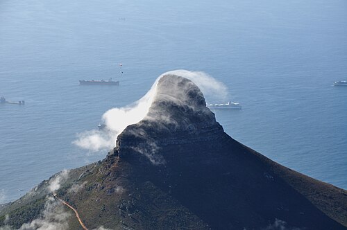
  1. Lion's Head Lion's Head
    02 20 min

    Lion's Head

    Lion's Head is a compact mountain peak overlooking Cape Town, South Africa. It stands adjacent to Table Mountain and forms part of the dramatic backdrop to the city.

    • Must see
    • Viewpoint
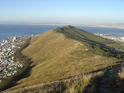
  2. Signal Hill Signal Hill
    03 20 min

    Signal Hill

    Signal Hill is a prominent low ridge located immediately beside Lion's Head in Cape Town, South Africa. It forms part of the dramatic mountainous backdrop that defines the city's skyline.

    • Must see
    • Viewpoint
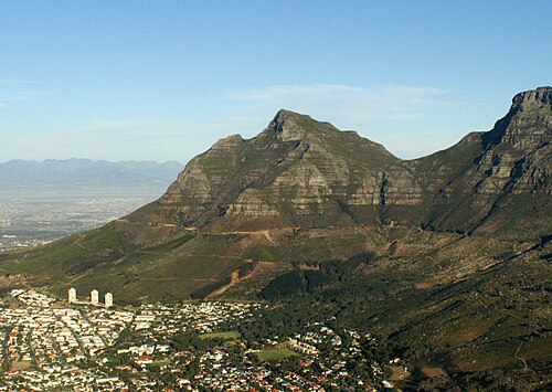
  3. Devil's Peak Devil's Peak
    04 20 min

    Devil's Peak

    Devil's Peak is a prominent mountain summit forming the eastern flank of Table Mountain in Cape Town, South Africa. It rises dramatically above the City Bowl and the university precinct, creating one of the most recognisable skylines in the city.

    • Must see
    • Viewpoint
  4. Kloof Corner Kloof Corner
    05 20 min

    Kloof Corner

    Kloof Corner is a short, steep hiking route on the lower slopes of Table Mountain in Cape Town, South Africa. It serves as a viewpoint hike offering elevated perspectives of the city, coastline, and mountain terrain.

    • Must see
    • Viewpoint

Source: OpenStreetMap contributors, Wikidata ·

How the city is laid out

The City Bowl forms the historic and commercial core beneath Table Mountain, with Bo-Kaap on its western slope and the V&A Waterfront north beside the harbour. The Atlantic Seaboard continues through Sea Point, Clifton and Camps Bay. Woodstock lies east, while Observatory, Newlands, Constantia and Kirstenbosch spread through the southern suburbs. Cape Point and the False Bay coast belong to a separate peninsula circuit rather than a central-city itinerary.

Checked 2026-08-26

Getting around

Walk within the City Bowl, Waterfront and individual neighbourhood clusters, then use MyCiTi buses, metered taxis, ride-hailing or a rental car between dispersed areas. Cape Town Tourism also identifies rail, minibus taxis and cycling among local options, but route suitability varies by destination. The peninsula, Constantia and some trailheads need deliberate transport planning; do not assume one central route connects every major sight.

Checked 2026-08-26

Common questions

How many days should I plan for Cape Town?

No fixed stay length is recorded. Plan separate blocks for the City Bowl and Waterfront, Table Mountain, the Atlantic Seaboard, the southern suburbs and any Cape Peninsula circuit.

Which Cape Town areas combine naturally?

The City Bowl, Bo-Kaap and V&A Waterfront combine most easily. Kirstenbosch and Constantia form a southern route, while Cape Point and False Bay need their own circuit.

Can I explore Cape Town on foot?

Walk within the City Bowl, Waterfront and individual neighbourhoods. Use a bus, taxi, ride-hailing service or car between the major zones spread around the mountain and coastline.

Does public transport reach every major Cape Town sight?

No single service connects every major sight conveniently. Some southern-suburb, peninsula and trailhead journeys require a transfer, taxi, tour or car.

How should weather affect a Cape Town itinerary?

Keep mountain and coastal activities flexible because wind and cloud can alter access. Pair each exposed plan with a museum, market or neighbourhood route.