
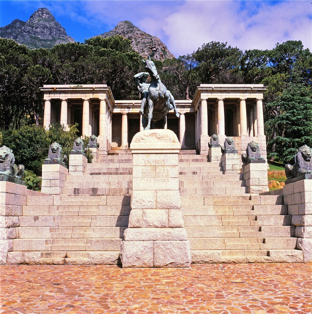
22 min walk
Rhodes Memorial
- Must see
- Historic monument
Language · 11 published
Viewpoint · Cape Town
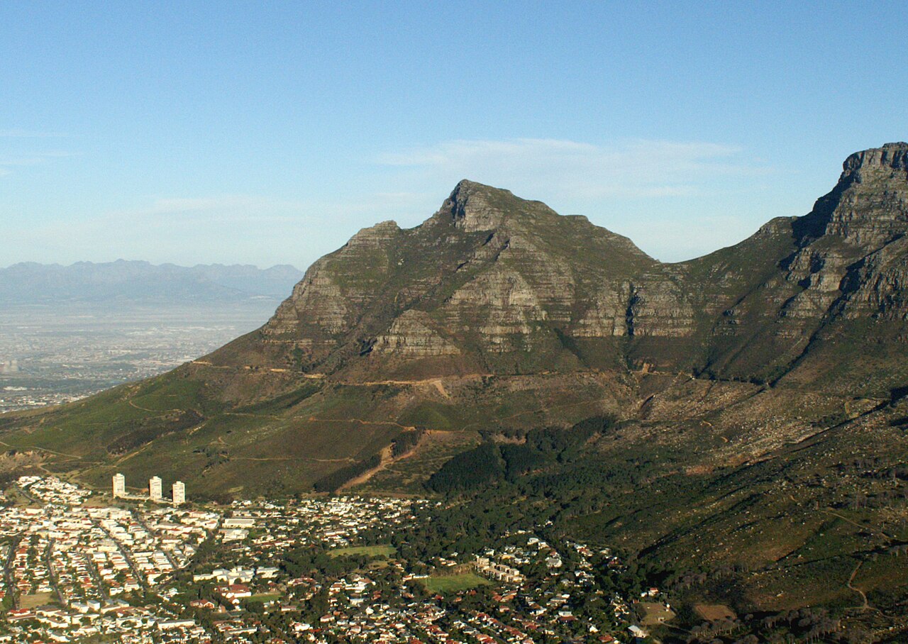
Devil's Peak is a prominent mountain summit forming the eastern flank of Table Mountain in Cape Town, South Africa. It rises dramatically above the City Bowl and the university precinct, creating one of the most recognisable skylines in the city. The peak is part of the Table Mountain National Park and serves as a major landmark visible from numerous vantage points across the metropolitan area. Its distinctive profile contributes significantly to Cape Town's dramatic natural setting. The strongest visit keeps attention on what is distinctive here while leaving room for the next stop. That approach makes Devil's Peak useful in both a focused first visit and a slower return to the city.
Checked 2026-08-26
The landscape comprises rugged mountain terrain with fynbos vegetation endemic to the Cape Floristic Region. Hiking trails traverse the slopes, offering access to viewpoints overlooking the city, harbour, and surrounding mountains. The upper reaches feature rocky outcrops and steep gradients characteristic of sandstone geology. The area supports diverse plant species adapted to the Mediterranean-type climate. No built structures or commercial facilities are present at the summit, preserving a wilderness character within an urban context. Devil's Peak also earns time in a cape town itinerary because The eastern Table Mountain flank is a prominent hiking and viewing landscape above the City Bowl and university precinct. Its value becomes clearer when the stop is compared with the surrounding streets and the other ranked places nearby.
Checked 2026-08-26
Hiking durations vary considerably depending on chosen route and individual fitness levels. The most direct paths from the city side typically require several hours of sustained ascent. Return journeys demand additional time and energy. Factors affecting duration include weather conditions, route selection, and rest stops. Visitors should assess their capabilities realistically and allow ample daylight for completion. Extended routes connecting to Table Mountain proper significantly increase total time requirements. Proper planning is essential for any excursion.
Checked 2026-08-26
The mountain environment experiences variable conditions regardless of season. Summer months bring intense solar exposure and occasional strong southeasterly winds. Winter introduces rain, mist, and reduced visibility. Early morning departures generally offer more stable conditions and reduced heat stress. Seasonal vegetation changes affect landscape character. Visitors must independently verify current access conditions and any restrictions through official channels before undertaking any hike, as circumstances may change without notice. A flexible visit lets travellers connect Devil's Peak with the rest of the day without treating one room, viewpoint or photograph as the whole experience. The useful pace depends on personal interest and conditions on arrival. Check the operator's own site for the travel date before relying on a schedule or fare.
Checked 2026-08-26
Access to Devil's Peak hiking routes falls within Table Mountain National Park jurisdiction. Fee structures, if applicable, may vary by entry point or activity type. Some access routes may require no payment. Visitors should consult official South African National Parks resources for current information. No commercial ticketing infrastructure is evident at trailheads. Any payment obligations should be verified through authoritative sources rather than assumed, ensuring compliance with conservation management requirements. Check the operator's own site for the travel date before relying on a schedule or fare.
Checked 2026-08-26
Multiple trailheads provide access from different directions. Routes from the city side commence near the university precinct and surrounding suburbs. Road access reaches various starting elevations. Public transport options serve some approach areas though connections may require walking. Private vehicle parking exists at certain trailheads with variable security conditions. Route selection should consider return logistics, as linear hikes may terminate at distant points. Topographic maps and local knowledge assist navigation. Signage quality varies across the network.
Checked 2026-08-26
Mountain weather deteriorates rapidly with temperature drops, wind acceleration, and sudden cloud formation. Navigation challenges increase in mist conditions. Terrain includes exposed sections with significant fall consequences. Summer fire risk demands awareness of restrictions and escape routes. Hydration requirements exceed expectations due to exertion and exposure. Mobile phone coverage is unreliable. Informing others of intended routes and return times is prudent. Solo hiking introduces additional risk factors. Equipment appropriate for mountain conditions is essential regardless of apparent weather at departure.
Checked 2026-08-26
The summit and slopes offer expansive perspectives encompassing Table Bay, the harbour, city centre, and the full Table Mountain chain. Sunrise and sunset lighting transforms the sandstone surfaces dramatically. Wide-angle lenses accommodate sweeping vistas while telephoto options isolate distant features. Atmospheric conditions significantly influence image quality, with clear days providing exceptional visibility. Wind stability affects tripod usability at exposed locations. The foreground vegetation and geological textures provide compositional interest. Golden hour duration varies seasonally, affecting planning for optimal illumination.
Checked 2026-08-26
Some routes are more demanding than others. Beginners should research specific trail difficulties, start with shorter options, and honestly assess fitness levels before attempting any ascent.
Physical access exists throughout the year, but weather conditions vary significantly. Personal safety assessments must determine appropriate timing for individual attempts.
Commercial guiding services operate in Cape Town. Visitors may engage professional guides for mountain activities, though specific offerings require independent verification.
Essential items include adequate water, weather-appropriate clothing layers, sun protection, basic first aid, navigation aids, and emergency contact arrangements. Requirements exceed casual walking preparations.
Natural water sources are not guaranteed safe for consumption. Visitors should carry sufficient water for entire excursions or employ appropriate purification methods if relying on found sources.
Mountain rescue capabilities exist in the region but response times depend on location accessibility, weather conditions, and available resources. Self-reliance and prevention remain paramount.
Loading the interactive map…
The interactive map could not be loaded.
Last updated:
Source: OpenStreetMap contributors, Wikidata ·