.jpg)
.jpg)

2 min walk
Robinsons Cybergate Cebu
- Notable
- Market
Language · 11 published
Historic monument · Cebu City
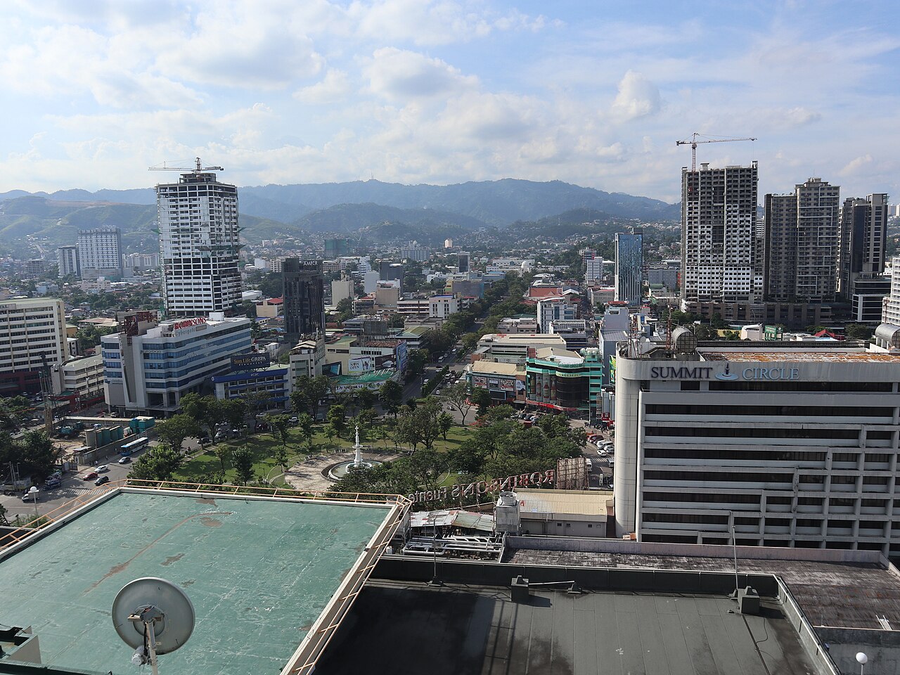
Fuente Osmeña Circle is a large urban roundabout and public space in Cebu City, Philippines. Named after the prominent Osmeña political family, it functions as one of the city's most recognized landmarks and a primary orientation point for residents and visitors. The circle features a central park area with a fountain monument at its core. It sits at a major intersection where several important city roads converge, making it a natural gathering place and reference point for navigation throughout the metropolitan area.
Checked 2026-08-26
The circle contains a central fountain monument dedicated to the Osmeña family legacy. Landscaped greenery and open space surround this focal point, providing limited shade in a tropical climate. Benches and walkways permit pedestrian circulation around the monument. The immediate vicinity includes commercial establishments, hotels, and government buildings. The circle itself is not enclosed; it remains fully accessible as public thoroughfare. No dedicated visitor facilities, interpretive signage, or staffed amenities are present within the traffic island itself.
Checked 2026-08-26
A brief circumambulation of the central monument requires approximately ten to fifteen minutes. Most visitors allocate thirty minutes to one hour for a leisurely visit including photography and observation of the surrounding traffic and city life. The site serves primarily as a transit point or brief stop rather than a destination requiring extended engagement. Visitors often combine this with exploration of nearby commercial districts, dining establishments, or other Cebu City attractions within walking distance of the circle.
Checked 2026-08-26
Operator-confirmed hours are Not recorded pending review. The circle functions as open public space without gates or controlled access, suggesting theoretical twenty-four-hour availability. However, pedestrian safety and visibility vary significantly by time of day. Daylight hours generally offer optimal conditions for observation, photography, and navigation. Evening visits may encounter reduced lighting in the central area. The fountain's operational schedule is not documented in available sources. Visitors should exercise standard urban precautions during all hours. Fuente Osmeña Circle also earns time in a cebu itinerary because Cebu's best-known civic circle and a central orientation point, though no exact POI is present. Its value becomes clearer when the stop is compared with the surrounding streets and the other ranked places nearby.
Checked 2026-08-26
Operator-confirmed prices are Not recorded pending review. No entrance fee structure is documented for this public traffic circle and park space. Access appears unrestricted and free of charge for pedestrians. No ticket booths, payment stations, or revenue collection infrastructure are described in available sources. Visitors should carry sufficient funds for incidental expenses in surrounding commercial areas. Any future changes to access policy would require verification through official Cebu City government channels or on-site observation. A flexible visit lets travellers connect Fuente Osmeña Circle with the rest of the day without treating one room, viewpoint or photograph as the whole experience. The useful pace depends on personal interest and conditions on arrival.
Checked 2026-08-26

Fuente Osmeña Circle occupies a central position in Cebu City where Osmeña Boulevard, Jones Avenue, and other major roads intersect. Multiple public utility jeepney routes pass through or near the circle, though specific route numbers require local verification. Taxis and ride-hailing services serve the area extensively. Walking access is feasible from numerous downtown hotels and commercial establishments. The circle's prominence as a landmark makes it a standard reference point for directing drivers. Traffic congestion is common during peak periods.
Checked 2026-08-26
Vehicular traffic presents the primary hazard; pedestrians must use designated crossings and remain alert when accessing the central island. The circle functions as an active roundabout with continuous vehicle flow from multiple directions. Limited shade and tropical sun exposure necessitate hydration and sun protection. Evening lighting conditions may reduce visibility. Standard urban precautions regarding personal belongings apply. The area experiences heavy traffic congestion during rush periods. No emergency services or security personnel are specifically assigned to this public space.
Checked 2026-08-26
The central fountain monument serves as the principal photographic subject, best captured during daylight hours when illumination is even. Wide-angle lenses accommodate the circular composition and surrounding traffic context. Elevated perspectives from nearby buildings may offer superior vantage points, though access requires separate arrangement. Night photography is complicated by variable lighting and safety considerations. The monument's white structure contrasts with tropical sky conditions. Pedestrians should secure equipment while photographing near active traffic lanes. No photography restrictions are documented.
Checked 2026-08-26
No entrance fee is documented. The circle functions as open public space without controlled access points or ticket infrastructure.
Operator-confirmed hours are Not recorded pending review. The space appears accessible at all times as an ungated public area, though conditions vary by hour.
Multiple jeepney routes serve the area. Specific route numbers require verification with local operators. Taxis and ride-hailing services are widely available.
The fountain's operational schedule is not documented in available sources. Functioning cannot be guaranteed for any specific visit.
Standard urban precautions apply. Lighting conditions vary. Visitors should assess personal comfort with nighttime conditions in active traffic environments.
No dedicated facilities are present within the traffic island. Commercial establishments in the immediate surrounding area provide such services.
Loading the interactive map…
The interactive map could not be loaded.

Last updated:
Source: OpenStreetMap contributors ·