Smart Self-Managed Tours

City guide · Peru

Lima

A photograph of Lima
Photograph · Corminos · CC BY-SA 3.0

Lima spreads along the Pacific coast and is best understood as several distant visitor clusters. The historic centre lies inland around Plaza Mayor; Miraflores and Barranco form the principal coastal corridor; San Isidro sits between the centre and the coast; and archaeological sites appear across the metropolitan area. Keep the historic centre, coastal districts and outlying ruins in separate blocks because traffic can make cross-city travel slow.

Practical information

Language spoken
Spanish; Quechua, Aymara and other Indigenous languages have official status where predominant
National practical orientation; regional and minority languages may also be used
Dialling code
+51
International calling code; local area and mobile prefixes still apply
Currency
Peruvian sol (PEN)
Use the official local currency; card acceptance varies by place
Emergency number
105 police · 116 fire
Use only for an emergency; tourist assistance may use a separate number
Plug type
Type A and C · 220 V
Check that chargers support the recorded voltage before using an adapter
Tap water
Not recorded
No verified nationwide visitor drinking-water statement was recorded

Turn this list into a plan

Set your days, your pace and the hours you actually want to be out. The planner works around closing days and travel time, and leaves room to eat.

Plan Lima

Planning a visit

Suggested stay
Not recorded
Getting around
Metropolitano, Metro, bus and authorised taxi
  1. January: best time to visit
  2. February: best time to visit
  3. March: best time to visit
  4. April: good time to visit
  5. May: good time to visit
  6. June: viable with meaningful trade-offs
  7. July: viable with meaningful trade-offs
  8. August: viable with meaningful trade-offs — current month
  9. September: viable with meaningful trade-offs
  10. October: good time to visit
  11. November: good time to visit
  12. December: best time to visit
  • Best time
  • Good time
  • Viable with trade-offs
  • Difficult conditions

Sources

Top things to see

Ranked by importance — sitelinks, pageviews and heritage status, not editor preference.

  1. Costa Verde Costa Verde
    02 2 hours

    Costa Verde

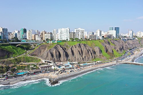
    Costa Verde is Lima's coastal corridor, a strip of land along the Pacific Ocean connecting multiple districts including Miraflores, Barranco, and Chorrillos. The area is defined by its dramatic high-cliff landscape that drops to beaches below.

    • Must see
    • Activity
  2. Palomino Islands Palomino Islands
    03 2 hours

    Palomino Islands

    The Palomino Islands are a small archipelago off the coast of Callao, Lima's principal port city.

    • Must see
    • Activity
  3. La Punta La Punta
    04 2 hours

    La Punta

    La Punta is a compact peninsula district within the constitutional province of Callao, adjacent to Lima.

    • Must see
    • Activity
  4. Aliaga House
    05 2 hours

    Aliaga House

    Casa de Aliaga stands as one of Lima's oldest continuously inhabited colonial houses, located near the historic Plaza Mayor in Peru's capital.

    • Must see
    • Activity
  5. Jirón de la Unión
    06 2 hours

    Jirón de la Unión

    Jirón de la Unión is a historic pedestrian street in central Lima, Peru. It serves as the traditional commercial spine connecting two of the city's most significant public squares: Plaza Mayor and Plaza San Martín.

    • Must see
    • Activity
  6. Paseo de Aguas
    07 2 hours

    Paseo de Aguas

    Paseo de Aguas is an eighteenth-century water promenade in Lima, Peru. It forms part of the extended Rímac heritage circuit situated north of the river.

    • Must see
    • Activity
  7. Acho Bullring
    08 2 hours

    Acho Bullring

    The Plaza de Toros de Acho is the historic bullring of Lima, situated in the Rímac district. Constructed in 1766, it stands as one of the oldest surviving bullrings in the Americas.

    • Must see
    • Activity
  8. Stone Bridge of Lima
    09 2 hours

    Stone Bridge of Lima

    The Puente de Piedra, or Stone Bridge of Lima, is a colonial-era bridge spanning the Rímac River in Peru's capital. It serves as a historic connection between Lima's historic centre and the Rímac district.

    • Must see
    • Activity
  9. National Library of Peru
    10 2 hours

    National Library of Peru

    The Biblioteca Nacional del Perú is Peru's national library and principal documentary institution. Headquartered in the San Borja district of Lima, it serves as the country's central repository for published works, manuscripts, and historical records.

    • Must see
    • Activity
  10. Pantanos de Villa Wildlife Refuge
    11 2 hours

    Pantanos de Villa Wildlife Refuge

    The Pantanos de Villa Wildlife Refuge, known locally as Refugio de Vida Silvestre Los Pantanos de Villa, is a protected wetland area situated within the metropolitan boundaries of Lima, Peru.

    • High
    • Activity
  11. Lomas de Lúcumo
    12 2 hours

    Lomas de Lúcumo

    Lomas de Lúcumo is a seasonal fog-fed hill ecosystem located on the southern outskirts of Lima, within the district of Pachacamac. These lomas formations represent one of the rare green landscapes in Peru's otherwise arid coastal desert.

    • High
    • Activity
  12. National Stadium of Peru
    13 2 hours

    National Stadium of Peru

    The Estadio Nacional del Perú is Peru's principal football stadium and a major civic landmark in Lima.

    • High
    • Activity

Source: OpenStreetMap contributors, Wikidata ·

How the city is laid out

The historic centre groups Plaza Mayor, churches, convents and civic buildings. Miraflores combines clifftop parks, commercial streets and Huaca Pucllana, while Barranco continues south with galleries, historic houses and the Bridge of Sighs. San Isidro has another archaeological and business cluster. Callao and distant huacas require additional travel. The official Lima guide presents these areas as distinct routes rather than one continuous old town.

Checked 2026-08-26

Getting around

Metropolitan buses, the Metropolitano corridor, Metro services and taxis connect Lima's districts, but journey times vary with traffic. Walk within the historic centre, Miraflores or Barranco, then use planned transport between clusters. Airport and Callao journeys need additional time and a confirmed route. Use authorised services and verify current transport information locally; a place that looks nearby on a metropolitan map may still involve a long road journey.

Checked 2026-08-26

Common questions

How is Lima organised for sightseeing?

the historic centre, Miraflores, Barranco and San Isidro are separate visitor clusters

How many days should I spend in Lima?

No fixed stay length is recorded; add blocks for central, coastal and outlying visits.

What is the easiest way to get around Lima?

Use public transport or an authorised taxi between the centre and coast, allowing for traffic.

Which places need a separate trip from central Lima?

Miraflores and Barranco form the most natural coastal pairing for one day.

What is the most practical way to plan a day in Lima?

No official best-month range is recorded; check current local conditions before travel.