
55 min walk
Flagstaff
- Notable
- Viewpoint
Language · 11 published
Viewpoint · Queenstown

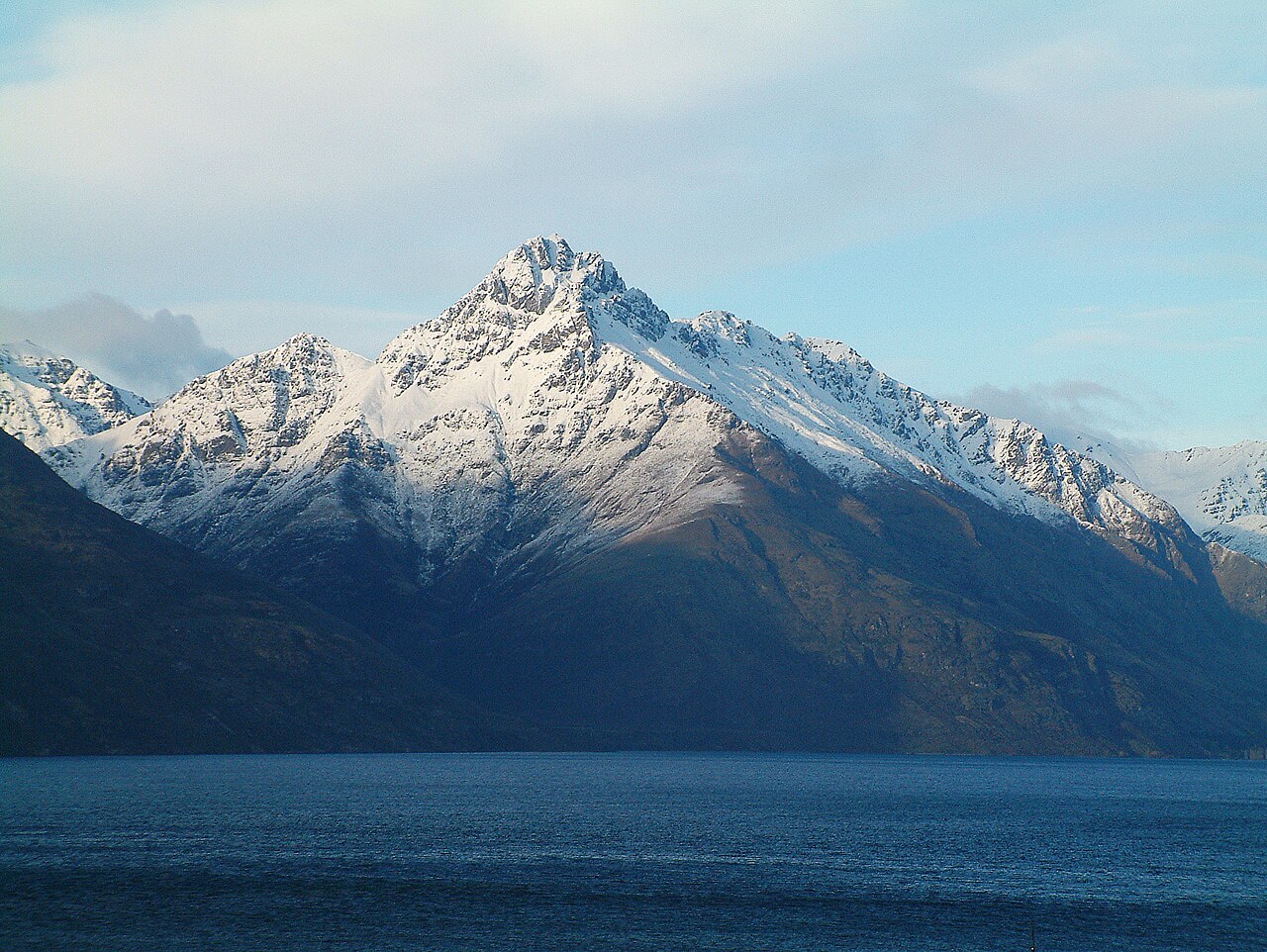
Cecil Peak is a prominent mountain on the western shore of Lake Wakatipu, directly opposite Queenstown. From town, its steep profile forms part of the skyline that makes the Southern Lakes landscape distinctive. For most travellers, Cecil Peak is a scenic landmark viewed across the water rather than a conventional attraction with a visitor entrance. It is a useful visual reference while exploring the Queenstown waterfront. Cecil Peak is a prominent mountain located on the western shore of Lake Wakatipu, directly opposite Queenstown township. It forms part of the distinctive skyline visible from much of the town and surrounding area. The peak rises steeply from the lakeshore and is one of the most recognisable landmarks in the Queenstown landscape. Its distinctive profile contributes significantly to the scenic character that draws visitors to the region. The mountain is named after a historical figure and remains an enduring symbol of the area's dramatic alpine geography. No direct walking route from Queenstown to Cecil Peak is documented. The peak lies across Lake Wakatipu, requiring water crossing and then unmarked terrain travel. No established trail network is recorded. No. Lake Wakatipu separates Queenstown from Cecil Peak. The practical sightseeing option is to view the mountain from town or from a lake-based activity.
Checked 2026-08-26 · Source
There is no interior exhibition at Cecil Peak. The place is a natural mountain environment of steep slopes, rocky ground, and alpine tussock, with Lake Wakatipu separating it from Queenstown. The place record does not identify a visitor centre, interpretive display, maintained trail system, hut, or other developed facility on the peak. Its principal experience is the mountain rising from the lake and the broad views around it. The terrain consists of alpine tussock, rocky outcrops, and steep slopes typical of the Southern Lakes district. Visitors should expect an undeveloped backcountry setting. The primary value lies in the visual prominence from Queenstown and the surrounding area rather than accessible interior features or amenities for casual exploration.
Checked 2026-08-26 · Source
Cecil Peak works well as a landmark to include during time at the Queenstown waterfront. Make it part of a broader lakeside walk or pause whenever the mountain is clearly visible. A direct approach is a different undertaking: the peak lies across Lake Wakatipu, and the place record does not identify a marked route or simple visitor access. Keep direct exploration separate from casual sightseeing and plan around the effort involved.
Checked 2026-08-26 · Source
Cecil Peak is visible from Queenstown throughout the year. View quality depends on cloud, rain, snow, wind, and changing light, all of which can alter the mountain's outline and the lake's surface. Clear weather gives the strongest definition, while unsettled conditions can make the scene atmospheric. If you plan a direct approach, treat alpine weather seriously and separate easy visibility from the difficulty of reaching the mountain.
Checked 2026-08-26 · Source
Viewing Cecil Peak from public areas around Queenstown does not require a peak admission ticket in the place information. Costs may arise from an optional activity used to change your viewpoint, such as transport on Lake Wakatipu or an organised mountain experience. Those are separate services, not an entrance fee for the natural landmark. The simplest way to enjoy Cecil Peak is to include its silhouette in free lakeside sightseeing.
Checked 2026-08-26 · Source
You do not walk directly from Queenstown to Cecil Peak because Lake Wakatipu lies between the town and the mountain. The accessible visitor experience is to view it from the Queenstown waterfront or another surrounding vantage point. Lake cruises can provide changing perspectives across the water. A direct approach would require water access followed by travel through mountain terrain, and no established public route is identified.
Checked 2026-08-26 · Source
Treat Cecil Peak as alpine backcountry if you move beyond viewing it from town. Steep ground, loose rock, snow, strong wind, sudden weather changes, and lake conditions can affect a direct approach. The place record does not identify maintained routes, emergency facilities, or mountain infrastructure. Bring experience and equipment appropriate to remote terrain, and plan a safe return. The mountain's appearance from Queenstown does not make access straightforward.
Checked 2026-08-26 · Source
Cecil Peak is a strong landscape subject from Queenstown's lakefront and elevated viewpoints. Frame the mountain with Lake Wakatipu in the foreground, then watch how cloud and changing light reshape the scene. Calm water may add reflections, while sunrise and sunset can separate the peak from surrounding ridges. A direct mountain viewpoint requires more planning. Keep photography unobtrusive and treat drone flights as subject to New Zealand aviation rules.
Checked 2026-08-26 · Source
No. Lake Wakatipu separates Queenstown from Cecil Peak. The practical sightseeing option is to view the mountain from town or from a lake-based activity.
No visitor centre or developed interpretive facility is identified in the place information. Cecil Peak is primarily a natural mountain landmark.
No peak admission ticket is identified for viewing Cecil Peak from public areas in Queenstown. Optional transport or organised activities may have separate costs.
The Queenstown waterfront and surrounding town viewpoints provide the easiest access. A lake cruise can add changing views across Lake Wakatipu.
Prepare for water access and alpine terrain. The place record does not identify a simple public route or maintained trail, and conditions may include steep ground, loose rock, snow, wind, and rapid weather changes.
Yes. The mountain is a prominent subject from the waterfront and elevated viewpoints. Lake foregrounds, reflections, cloud, and changing light add variety to the composition.
Loading the interactive map…
The interactive map could not be loaded.

Last updated:
Source: OpenStreetMap contributors, Wikidata ·