Smart Self-Managed Tours

City guide · Canada

Toronto

A photograph of Toronto
Photograph · Jchmrt · CC BY-SA 4.0

Toronto is a city of neighbourhoods arranged around a compact downtown and long transit corridors. The City Centre contains the financial, entertainment and waterfront districts; Old Town lies east, the Westside extends through Queen West and beyond, and Midtown and Uptown follow the main north-south axes. Toronto Islands, Scarborough and Etobicoke are separate trips. Group downtown sights on foot and use the TTC for wider movement.

Practical information

Language spoken
English and French
National practical orientation; regional and minority languages may also be used
Dialling code
+1
International calling code; local area and mobile prefixes still apply
Currency
Canadian dollar (CAD)
Use the official local currency; card acceptance varies by place
Emergency number
911
Use only for an emergency; tourist assistance may use a separate number
Plug type
Type A and B · 120 V
Check that chargers support the recorded voltage before using an adapter
Tap water
Not recorded
Water systems and advisories are managed by multiple jurisdictions

Planning a visit

Suggested stay
Not recorded
Getting around
Walk and use TTC subway, streetcar and bus services
  1. January: no seasonality data recorded
  2. February: no seasonality data recorded
  3. March: no seasonality data recorded
  4. April: no seasonality data recorded
  5. May: no seasonality data recorded
  6. June: no seasonality data recorded
  7. July: no seasonality data recorded
  8. August: no seasonality data recorded — this month
  9. September: no seasonality data recorded
  10. October: no seasonality data recorded
  11. November: no seasonality data recorded
  12. December: no seasonality data recorded

Top things to see

Ranked by importance — sitelinks, pageviews and heritage status, not editor preference.

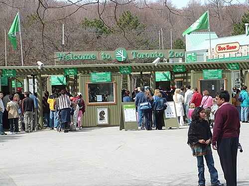
  1. Toronto Zoo Toronto Zoo
    02 1 hr 30 min

    Toronto Zoo

    Toronto Zoo is Canada's largest zoo and a major Greater Toronto family attraction. The current Toronto research set places this exact production identity within the city's first ten publishable matches.

    • Must see
    • Family attraction
  2. Riverdale Farm Riverdale Farm
    03 1 hr 30 min

    Riverdale Farm

    Riverdale Farm is a working heritage farm situated in Toronto's Cabbagetown neighbourhood. It occupies a site that was formerly part of the Riverdale Zoo, which relocated in 1974 to become the Toronto Zoo.

    • Must see
    • Family attraction
  3. High Park Zoo High Park Zoo
    04 1 hr 30 min

    High Park Zoo

    High Park Zoo is a free small zoo located within High Park in Toronto, Ontario. It operates as a distinct family stop within the larger municipal park.

    • Must see
    • Family attraction
  4. Reptilia
    05 1 hr 30 min

    Reptilia

    • Notable
    • Family attraction
  5. Big Al's
    10 1 hr 30 min

    Big Al's

    • Notable
    • Family attraction
  6. Relax Spa
    22 1 hr 30 min

    Relax Spa

    • Notable
    • Family attraction
  7. Twiga Zoomo
    27 1 hr 30 min

    Twiga Zoomo

    • Notable
    • Family attraction
  8. Water Q Spa
    28 1 hr 30 min

    Water Q Spa

    • Notable
    • Family attraction
  9. Zen Spa
    30 1 hr 30 min

    Zen Spa

    • Notable
    • Family attraction

Source: OpenStreetMap contributors, Wikidata ·

How the city is laid out

Lake Ontario forms Toronto's southern edge, with the downtown core immediately north of the waterfront. The Entertainment District and Financial District sit centrally; Old Town and the Distillery District are east, while Queen West, Ossington and High Park extend west. Midtown and Uptown follow Yonge Street north. The Toronto Islands require a ferry, and Scarborough and Etobicoke sit well outside the central walking area.

Checked 2026-08-26

Getting around

Walk through the compact downtown and use the TTC subway, streetcars and buses for longer journeys. Streetcars are particularly useful across east-west neighbourhood corridors, while the subway handles the principal north-south and cross-city axes. The PATH provides an underground pedestrian network through the downtown core. Ferries serve the Toronto Islands, and regional rail is useful for airport and Greater Toronto connections.

Checked 2026-08-26

Common questions

How many days should I spend in Toronto?

A fixed stay length is not recorded. Plan the downtown and waterfront first, then add neighbourhoods, Toronto Islands or an outer district according to your interests.

Is downtown Toronto walkable?

Yes. The City Centre, waterfront, Old Town and nearby westside districts are accessible on foot, with the TTC available for longer links.

What is the best way to get around Toronto?

Use a combination of walking and TTC subway, streetcar and bus services. The network connects downtown with neighbourhoods along the city's main corridors.

What is the PATH?

PATH is an underground pedestrian network through downtown Toronto. It links buildings and services and can provide a sheltered walking option in poor weather.

Can I walk to the Toronto Islands?

No. The islands are offshore and require a ferry or another authorised water connection. Treat them as a separate excursion from the downtown waterfront.

Turn this list into a plan

Set your days, your pace and the hours you actually want to be out. The planner works around closing days and travel time, and leaves room to eat.

Plan Toronto