
212 min walk
Pura Agung Besakih
- Must see
- Place of worship
Language · 11 published
Viewpoint · Denpasar
| Monday | 00:00 – 23:59 |
|---|---|
| Tuesday | 00:00 – 23:59 |
| Wednesday | 00:00 – 23:59 |
| Thursday | 00:00 – 23:59 |
| Friday | 00:00 – 23:59 |
| Saturday | 00:00 – 23:59 |
| Sunday | 00:00 – 23:59 |
Checked 2026-08-31 · Source
Read from the OpenStreetMap access tags; anything not listed has no tag recorded.
Set the group type to family in the planner and the day window contracts to about three quarters of a solo day.
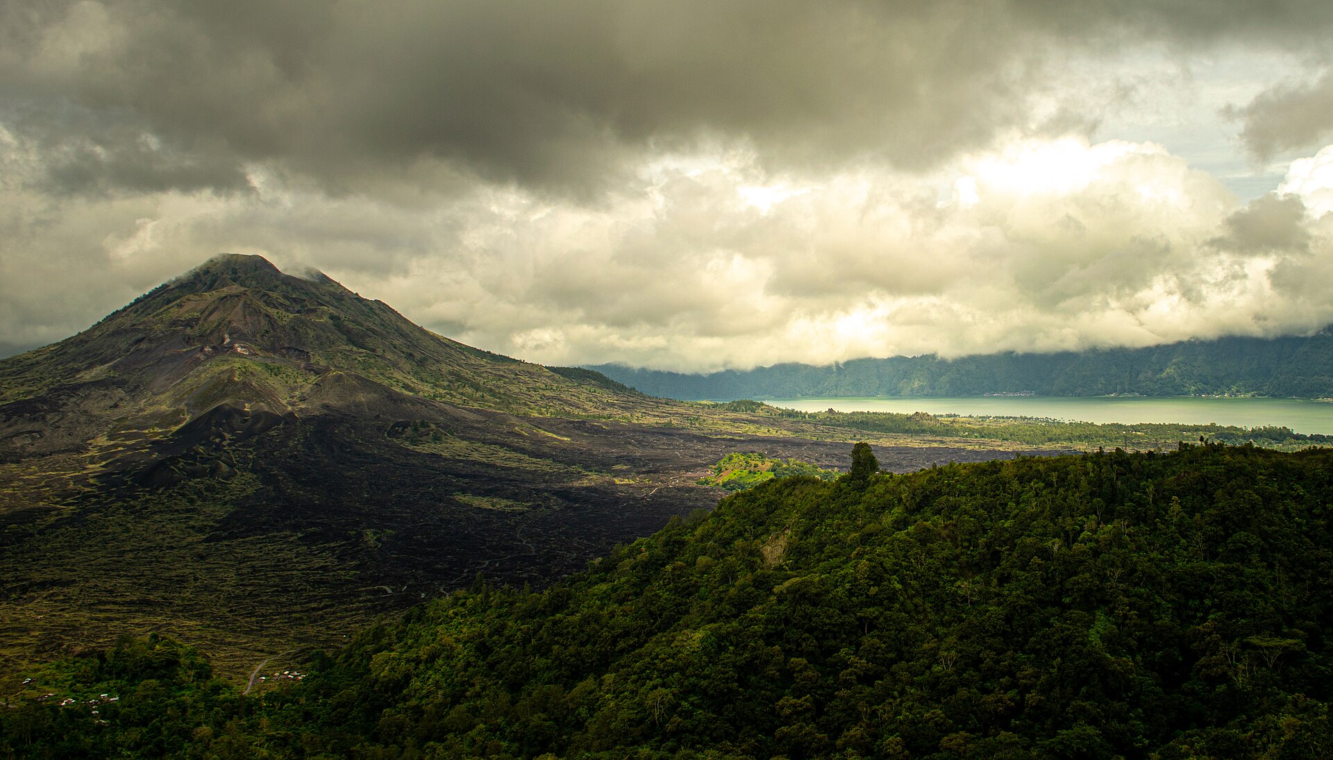
Mount Batur, known locally as Gunung Batur, is an active volcano located in Bali, Indonesia. It sits within the Batur UNESCO Global Geopark, recognized for its significant geological heritage. The volcano rises prominently in the Kintamani district northeast of Denpasar. Its caldera contains Lake Batur, forming a distinctive landscape of volcanic and aquatic features. The mountain holds spiritual importance for Balinese Hindus and attracts visitors seeking trekking experiences. Daily: 24 hours (WITA). BKSDA Bali recorded active visits on 16–17 August 2026. The 2026 Nyepi closure ran from 18 through 20 March; the reserve reopened on 21 March at 09:00 WITA.
Checked 2026-08-31 · Source
The Batur caldera complex encompasses several notable features. Lake Batur occupies part of the caldera floor, serving as a water source and supporting local fisheries. Multiple volcanic cones exist within the caldera, including the central summit crater. Hot springs emerge in surrounding areas, utilized by local communities. The geopark contains diverse volcanic rock formations and lava flows from historical eruptions. Traditional villages maintain presence on caldera rims, with agricultural terraces visible on slopes. BKSDA Bali recorded active visits on 16–17 August 2026. The 2026 Nyepi closure ran from 18 through 20 March; the reserve reopened on 21 March at 09:00 WITA.
Checked 2026-08-31 · Source
Summit treks from trailheads typically require several hours of walking, with most visitors completing the ascent in time for sunrise viewing. The total excursion duration depends on starting point, pace, and whether guided services are employed. Many visitors arrange overnight departures from Denpasar or nearby accommodations to reach the trailhead before dawn. Descent adds comparable time to the return journey. Combined with transportation from Denpasar, the full experience commonly extends across much of a day. Indonesian visitors: IDR 10,000 per person Monday–Saturday and IDR 15,000 on Sundays and public holidays. International visitors: IDR 100,000 per person. The Culali ticket post accepts cashless payment.
Checked 2026-08-31 · Source
Dry season months generally offer more favorable trekking conditions with reduced rainfall probability, though weather remains variable at elevation. Sunrise treks constitute the most common visitor pattern, requiring predawn commencement. Visibility conditions fluctuate; morning clouds may obscure views regardless of season. The rainy season presents increased mud and slip hazards on trails. Daily: 24 hours (WITA). For public transport from Denpasar, the city’s official transport chart directs Kintamani-bound services through Batubulan Terminal. From Penelokan, continue by road toward Toya Bungkah/Toya Batur. Vehicles can reach designated parking or a selected trailhead; official access points in the area include Toya Bungkah, Serongga, Culali, P3GB, and Pasar Agung.
Checked 2026-08-31 · Source
Access to Mount Batur trekking routes involves local fees and guide requirements, though specific structures vary. Multiple local guide associations operate in the area, with arrangements typically made through accommodations or designated offices. Additional costs may apply for transportation to trailheads. Visitors should verify current requirements upon arrival rather than relying on published rates that may have changed. Indonesian visitors: IDR 10,000 per person Monday–Saturday and IDR 15,000 on Sundays and public holidays. International visitors: IDR 100,000 per person. The Culali ticket post accepts cashless payment. The summit is reached by a hiking trail rather than a step-free route.
Checked 2026-08-31 · Source
Mount Batur lies approximately two hours by road from Denpasar, depending on traffic and exact origin point. Private vehicle hire represents common transport method, with drivers familiar with predawn departure schedules. No direct public transportation reaches trailheads conveniently for sunrise treks. For public transport from Denpasar, the city’s official transport chart directs Kintamani-bound services through Batubulan Terminal. From Penelokan, continue by road toward Toya Bungkah/Toya Batur. Vehicles can reach designated parking or a selected trailhead; official access points in the area include Toya Bungkah, Serongga, Culali, P3GB, and Pasar Agung.
Checked 2026-08-31 · Source
Active volcanic status necessitates awareness of current alert levels and official guidance. Trail conditions include loose volcanic scree and steep sections requiring appropriate footwear. Predawn darkness demands reliable light sources. Temperatures at summit differ substantially from Denpasar lowlands; layered clothing is essential. Local guide accompaniment is typically mandatory and provides navigational assistance. Altitude effects, while moderate, may affect some visitors. The summit is reached by a hiking trail rather than a step-free route. Motor vehicles reach only designated parking or trailhead areas; the summit section continues on foot.
Checked 2026-08-31 · Source
Summit vantage offers panoramic caldera and lake views when atmospheric conditions permit. Sunrise illumination on volcanic terrain creates distinctive lighting, though cloud interference is common. Wide-angle lenses accommodate expansive landscape compositions. Predawn darkness requires stable support for long exposures. The contrast between volcanic rock, lake water, and distant peaks provides structural elements. Morning mist can obscure or enhance scenic qualities unpredictably. Flash photography is inappropriate in culturally sensitive areas. Battery performance may diminish in cooler summit temperatures. The summit is 1,717 metres above sea level. Indonesia’s tourism ministry gives an approximate ascent time of 2.5 hours.
Checked 2026-08-31 · Source
The Ministry of Energy and Mineral Resources lists Mount Batur at Level I (Normal). Visitors must not stand on the crater rim or enter fumarole areas on the slopes because volcanic gases can reach dangerous concentrations.
The summit is 1,717 metres above sea level.
Indonesia’s tourism ministry gives an approximate ascent time of 2.5 hours.
The official visitor guidance describes the route as rocky and sandy and says it requires good physical condition and appropriate footwear.
BKSDA Bali identifies Culali as the cashless ticket post for TWA Gunung Batur Bukit Payang.
BKSDA Bali deployed personnel at Pura Jati, Pasar Agung, and the summit during the August 2026 holiday period; the district spatial plan also names Toya Bungkah, Serongga, Culali, and P3GB as trekking-access locations.
Loading the interactive map…
The interactive map could not be loaded.

Last updated:
Source: OpenStreetMap contributors ·