

.jpg)


9 min walk
Sanctuary on San Cristóbal Hill
- Must see
- Place of worship
Language · 11 published
Viewpoint · Santiago
Cerro San Cristóbal

Cerro San Cristóbal is a prominent hill rising within Santiago's Metropolitan Park, recognized as the city's defining urban viewpoint. The hill offers panoramic vistas across the Chilean capital toward the Andes Mountains. It serves as a central landmark for the park system and holds cultural significance through its religious monuments. Visitors access the summit via multiple transport modes. The hill forms part of the larger urban green space that provides recreational opportunities for residents and tourists. Its elevation makes it a natural orientation point within the sprawling metropolitan area.
Checked 2026-08-26
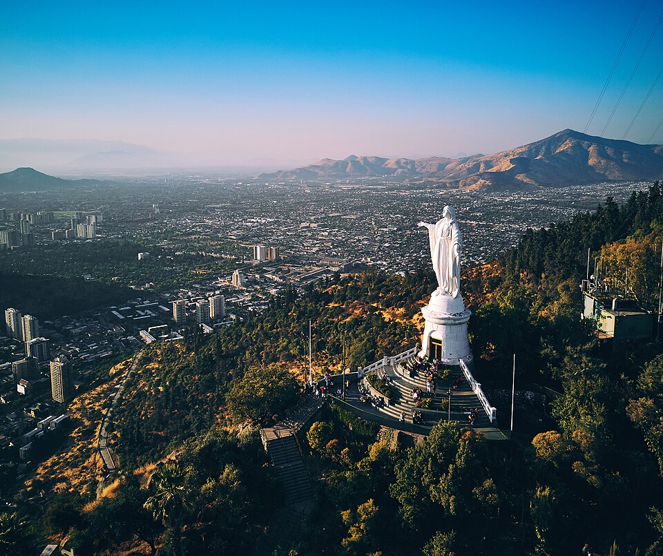
The hill contains several notable features including the white marble statue of the Virgin Mary at its summit. Terraced gardens, walking paths, and viewing platforms occupy various elevations. A small chapel sits near the statue. The Metropolitan Park encompasses additional attractions beyond the hill itself, including botanical collections and recreational facilities. Swimming pools operate seasonally in the lower park areas. The funicular railway and cable car provide transport options. Religious pilgrimage traditions associate with the summit monument. The hill's developed areas contrast with remaining natural slopes.
Checked 2026-08-26
Visitors typically allocate half a day for a meaningful visit to Cerro San Cristóbal, combining ascent, summit exploration, and descent. Those using the funicular or cable car reduce transit time significantly compared to walking. Extended stays incorporate adjacent Metropolitan Park attractions or picnic periods. Fitness levels and transport choices substantially affect duration. The summit viewpoint rewards unhurried observation, particularly during atmospheric conditions that clarify distant mountain views. Photographers and those seeking contemplative time may prefer longer visits. Morning and afternoon sessions each offer distinct lighting qualities for observation.
Checked 2026-08-26

Operator-confirmed hours are Not recorded pending review. Santiago's Mediterranean climate brings warm, dry summers and mild, wet winters. Clear atmospheric conditions favor visibility toward the Andes, making certain days superior for panoramic viewing. Morning hours often provide cleaner air before urban activity accumulates. Winter snow on distant peaks enhances scenic drama when visibility permits. Summer heat demands hydration preparation for exposed summit areas. Spring and autumn offer moderate temperatures. Smog accumulation during winter thermal inversions can obscure distant views regardless of season. Visitors should verify current operational status before planning.
Checked 2026-08-26
Operator-confirmed prices are Not recorded pending review. The funicular railway and cable car systems typically require separate fares from general park access, though specific pricing structures remain unverified. Some park areas may operate with free entry while mechanized transport incurs charges. Combination arrangements between transport modes may exist. Visitors should prepare for potential queuing during peak visitation periods. Payment methods accepted at on-site facilities are not confirmed. Group rates, children's fares, and any temporal pricing variations require direct operator verification. Budget flexibility accommodates uncertainty until authoritative pricing information becomes available.
Checked 2026-08-26

Multiple access points serve Cerro San Cristóbal within the Metropolitan Park system. The funicular railway ascends from the Bellavista neighborhood on the hill's western approach. A cable car system connects from alternative access points. Public bus services reach park entrances. Walking routes from surrounding neighborhoods provide pedestrian access for those prepared for elevation gain. Cycling paths exist within the broader park network. Private vehicle parking availability at various elevations requires confirmation. The hill's central location within Santiago makes it accessible from multiple districts. Visitors should identify their preferred transport mode before departure.
Checked 2026-08-26

Sun exposure at the exposed summit demands protective measures regardless of perceived temperature. Elevation gain affects visitors unaccustomed to physical exertion at altitude. Crowding concentrates around the summit statue and transport terminals during peak periods. Personal belongings require attention in busy areas. Path conditions vary between maintained routes and natural surfaces. Weather changes can occur rapidly with elevation. Water availability should be confirmed before ascent. The funicular and cable car have capacity limitations that create waiting times. Dismounting from transport systems requires care. Night visitation presents additional considerations for navigation and safety.
Checked 2026-08-26
The summit offers Santiago's premier urban panorama, with the Andes as backdrop when atmospheric clarity permits. The white Virgin Mary statue provides architectural subject matter against sky or city contexts. Golden hour lighting from either direction creates distinct moods. Wide-angle lenses accommodate expansive vistas while telephoto lenses compress city layers against mountain silhouettes. Haze and smog affect image clarity unpredictably. Tripod use may face practical constraints in crowded summit areas. The funicular journey presents sequence possibilities. Garden terraces and path perspectives offer alternatives to direct summit views. Weather contingency improves success rates for dedicated photography sessions.
Checked 2026-08-26
Cerro San Cristóbal is a hill within the larger Metropolitan Park system. The park encompasses additional areas beyond this central hill.
Walking routes exist from surrounding neighborhoods, though the elevation gain requires appropriate fitness preparation. The funicular and cable car provide alternatives.
The white Virgin Mary statue at the summit is visible from many points across Santiago, functioning as an orientation landmark.
Specific food service facilities at the summit are not confirmed in available sources. Visitors should prepare accordingly.
Seasonal operational schedules for the funicular and cable car are not recorded pending operator confirmation.
Atmospheric conditions including urban smog and winter thermal inversions can substantially reduce visibility toward the Andes and across the city.
Loading the interactive map…
The interactive map could not be loaded.


Last updated:
Source: OpenStreetMap contributors, Wikidata ·