
11 min walk · Salihli
Bin Tepe
- Must see · Heritage site
- Historic monument
Language · 1 published
Historic monument · Salihli, Manisa
Giges Tümülüsü
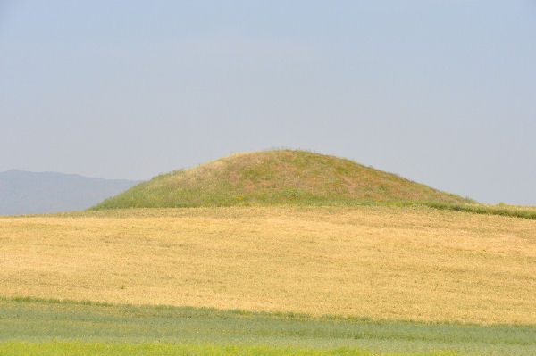
The Tumulus of Gyges — Giges Tümülüsü on local maps, and known archaeologically as Karnıyarık Tepe — is the second-largest of the more than a hundred royal Lydian mounds gathered in the Bin Tepe field north of Sart, in Salihli district. The name comes from the Greek poet Hipponax, who linked a great mound at this cemetery to Gyges, the king Herodotus made famous as the founder of the Mermnad dynasty in the seventh century BC. Modern excavation has undercut the attribution: pottery recovered from the mound's fill dates its construction to after roughly 600 BC, decades after Gyges died around 644 BC, so the king whose name the tumulus carries cannot be the person buried inside it. Bin Tepe and Sardis were inscribed together on the UNESCO World Heritage List on 12 July 2025, and this mound is part of that listed landscape.
Checked 2026-08-24 · Source
The mound itself is enormous: 230 metres across and 53 metres high on its southern side, a footprint close to the Great Pyramid's at Giza. Excavation has shown the builders first laid out a smaller mound about 85 metres across, then abandoned that plan partway through and expanded the project to nearly triple its diameter, leaving an unfinished limestone retaining wall — a krepis — buried inside the larger mound rather than on its visible surface. Decades of tunnelling, from geophysical surveys and probe work in the 1960s through renewed tunnelling in 2012 carried out jointly with the Manisa Museum, have driven more than half a kilometre of passages toward the centre without finding a burial chamber. Roman-period tomb robbers dug their own tunnels into the mound long before that, and the marks their workers left on the stone, including carved swastika symbols, are still visible on the reinforced krepis wall today.
Checked 2026-08-24 · Source
This is a short visit by design, not by neglect: there is no chamber to enter and no museum on site, just an immense earthen mound standing alone in farmland. Fifteen to twenty minutes is enough to walk its base and take in the scale, which is the point of coming — the size only reads properly in person, from close up, where the mound fills the whole horizon in a way no photograph taken at ground level manages to convey.
Checked 2026-08-24
The site is an open field with no shade and no facilities, so the same logic that applies to Sardis Acropolis applies here: go outside the midday heat, and be aware that farm tracks around the mound can turn to mud after rain, making the approach harder in wet weather than the short walking distance suggests.
Checked 2026-08-24
There is no ticket, no fence and no gate. The tumulus sits in open agricultural land and is currently accessible without any entry formality — it is not administered as a ticketed site the way Sardis is. Nothing beyond common courtesy toward the surrounding farmland is required to reach it.
Checked 2026-08-24 · Source
Bin Tepe lies in the Gediz plain north of Sart, toward Marmara Lake, in Salihli district, roughly sixty to sixty-five kilometres east of Manisa city. There is no metro, no useful rail and no bus route that reaches the mound itself — a car is necessary, following unmarked farm roads off the main Salihli road once past Sart.
Checked 2026-08-24 · Source
The land around the mound is working farmland, not a managed archaeological park, so there is no marked path and no signage pointing the way in — a car with a downloaded map or offline GPS point matters more here than the short distance implies. The mound's slopes are eroded and there is no barrier keeping visitors off them, so footing should be treated with the same care as any steep, unmaintained earthwork.
Checked 2026-08-24 · Source
Ground-level shots struggle to convey a mound this size — 53 metres is taller than most European church spires, and standing at its base compresses that height into something that reads as an ordinary hill in a photograph. Stepping back to include a person or a car at the base for scale, or shooting from a neighbouring rise in the Bin Tepe field, does more for the sense of size than a close frame does. Other mounds in the same field sit within sight of this one, so a wide shot that catches two or three of them together says more about Bin Tepe as a cemetery than any single frame of Karnıyarık Tepe alone can.
Checked 2026-08-24
No, or at least not provably. The mound carries Gyges's name from the ancient poet Hipponax, but pottery from its fill dates construction to after about 600 BC, decades after Gyges died around 644 BC, which rules him out as the person buried inside.
230 metres in diameter and 53 metres high on its southern side, a footprint close to the Great Pyramid of Giza's — the second-largest of the Bin Tepe tumuli.
No. Decades of scientific tunnelling have not located a burial chamber, and none of the passages, ancient or modern, are open to the public.
Yes. Bin Tepe was inscribed together with Sardis on the UNESCO World Heritage List on 12 July 2025.
Unresolved. The mound's royal scale and its construction date, after Gyges's reign, point toward another member of the Lydian royal family — a later king such as Alyattes or possibly a queen — but no excavation has identified an occupant.
By car, roughly sixty to sixty-five kilometres east through Salihli district, on unmarked farm roads north of Sart — there is no bus or rail service that reaches the mound itself.
Loading the interactive map…
The interactive map could not be loaded.
Last updated:
Source: OpenStreetMap contributors ·