
105 min walk · Salihli
Çakallar
- High
- Historic monument
Language · 1 published
Viewpoint · Kula, Manisa
Divlit Yanardağı
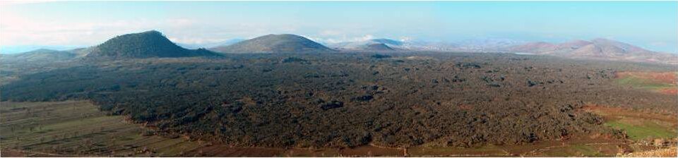
Divlit Yanardağı, known locally as Çakallar Tepesi or Divlittepe, is a cinder cone on the shore of the Demirköprü Reservoir in Kula district, at roughly 750 m above sea level. Wikidata records it as part of the Kula-Salihli Geopark, the same UNESCO Global Geopark that covers Kula Volcano, but the two cones sit roughly 20 km apart and are reached by different roads. Turkish sources describe Divlit Yanardağı as the youngest formation of Kula volcanism, the cone on whose slope the now-abandoned village of Çakallar once stood, and the site where the field's ancient human footprints were found.
Checked 2026-08-24 · Source
There are two cones here, not one: the larger, called Çakallar Tepesi or Divlittepe, and a smaller cone known locally as Küçük Divlit about a kilometre away, both rising directly from the reservoir shoreline. The abandoned village of Çakallar sits on the larger cone's slope.
This is also where more than 200 fossilised human footprints were uncovered in 1968, when workers excavating scoria for the Demirköprü dam found them pressed into volcanic ash, with a stride recorded as long enough that two people are thought to have walked side by side across it. Their age is disputed rather than settled. Tekkaya's 1976 study, the figure both the Turkish and English Wikipedia articles carry, dates them to roughly 10,000-12,000 years old — among the oldest known human footprints in Anatolia on that reading. A 2019 study using cosmogenic chlorine-36 and zircon dating on the same volcanic deposits instead places the eruption that buried them at about 4,700 years ago, in the Bronze Age (3000-1200 BC), a figure MTA now cites for the field. This page reports both rather than blending them into one number. The surrounding ground is described as badlands of volcanic and lake sediment, with eroded lava cones, lava flows and fairy-chimney-like erosion typical of the wider field.
Checked 2026-08-24 · Source
This is a half-day trip rather than a quick stop: the site sits well outside Kula town on unpaved roads, and there is nothing to rush toward once there beyond the two cones and the shoreline. Allow at least two to three hours from leaving Kula, including the drive, and more if both cones and the footprint area are walked rather than viewed from the car.
Checked 2026-08-24
Dry weather matters more here than at the more accessible sites in the geopark, since the final approach is unpaved and softens after rain. The reservoir's water level and shoreline shift with the season, so how close the cones sit to open water varies through the year, and no fixed schedule for that is published on the sources this page uses. Spring and autumn keep the exposed cinder slopes cooler than summer, which has no shade at any point on the route.
Checked 2026-08-24
There is no ticket for Divlit Yanardağı: it is unmanaged shoreline and open volcanic terrain, not a gated monument, and the footprint site itself has no ticket booth or staffed entrance documented in the sources this page uses. Current opening arrangements or any fee for the wider geopark's facilities are not published there either. The same geopark protection applies here as everywhere else in the field: nothing is taken from the ground, and vehicles keep to existing tracks rather than crossing the cones or the shoreline.
Checked 2026-08-24 · Source
Kula is about 100 km east of Manisa city on the road toward Uşak, with no rail or metro service. From Kula town, the site is reached by continuing further east and north, off the road between Salihli and Demirci, roughly 25 km northeast to the Demirköprü Reservoir shoreline. A car is required for the whole approach — there is no bus route to the cones themselves, and the last stretch runs on unpaved tracks. This is the more remote of the two Kula cones covered on this site, and it should not be treated as a quick add-on to a day built around Kula town.
Checked 2026-08-24 · Source
The unpaved final approach is the main hazard: it can be rutted, and after rain an ordinary car may not manage it. The reservoir shoreline itself is unmanaged, so footing near the waterline is uneven and the water level is not fenced or marked. The footprint site is a documented paleontological find, not a display behind glass, and the sources this page uses describe no barrier around it; visitors should stay off any fossil surface and treat it as the protected geological record it is. As at every geosite in this geopark, nothing is removed from the ground and vehicles stay on existing tracks.
Checked 2026-08-24
The pairing of a dark volcanic cone against the reservoir's open water is the distinctive shot here, and it reads best with the water calm, typically in the early morning before wind picks up on the lake. The abandoned village of Çakallar on the larger cone's slope photographs as a ruin against bare cinder rather than as a picturesque village, which is the honest description rather than the flattering one. No photography restriction is documented for the site; drone use should be checked against current Turkish aviation rules independently, since none of the sources here cover it.
Checked 2026-08-24
A cinder cone on the shore of the Demirköprü Reservoir in Kula district, also called Çakallar Tepesi or Divlittepe locally, and part of the Kula-Salihli Geopark.
The footprints were documented at this site in 1968. The sources this page uses do not confirm whether the original prints remain visible on the ground today or have been moved for conservation, so check with the geopark visitor center before making a special trip to see them.
Disputed. A 1976 study, the figure both Wikipedias carry, dates them to 10,000-12,000 years old. A 2019 study using cosmogenic and zircon dating on the same volcanic deposits instead dates the eruption that buried them to about 4,700 years ago, in the Bronze Age. This page states both rather than choosing one.
No. They are distinct cones roughly 20 km apart inside the same Kula-Salihli Geopark, reached by different roads from Kula town.
Not necessarily in dry weather, but the final approach is unpaved and can be difficult for an ordinary car after rain, so higher clearance is safer.
No. It is open shoreline and volcanic terrain rather than a ticketed site, and no admission fee is documented for it.
Loading the interactive map…
The interactive map could not be loaded.
Last updated:
Source: OpenStreetMap contributors, Wikidata ·