Aussichtspunkt · Döbling, Vienna
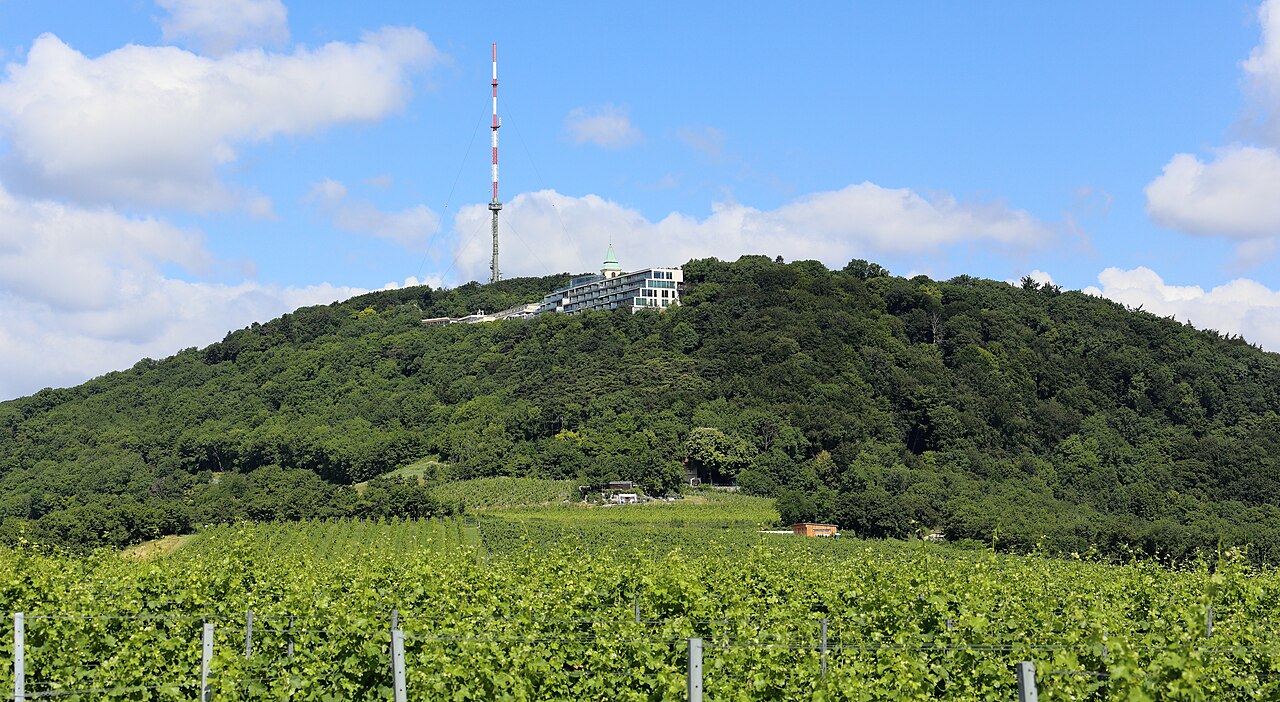
Kahlenberg
Foto
_-_Kahlenberg.JPG)
- Heute
- Öffnungszeiten nicht erfasst
- Besuchsdauer
- 1 Stunde
- Barrierefreiheit
- Nicht erfasst
- Preis
- Nicht erfasst
- Einordnung
- Hoch
- Rang
- Rang 2,756 von 5,640
Über Kahlenberg
Kahlenberg is a 484 m hill on the northern rim of the Vienna Woods and the city's most visited viewpoint, looking south over the whole basin the Innere Stadt sits in and east across the Danube towards the Marchfeld plain.
The ridge carries the name into the events of 12 September 1683: the relief army under King John III Sobieski of Poland assembled along this line of hills before descending to break the second Ottoman siege of Vienna. A church has stood on the summit since the early seventeenth century, rebuilt more than once, and is still dedicated to Saint Joseph.
The lower slopes on the Grinzing side carry vineyards, and Kahlenberg sits inside the Vienna Woods Biosphere Reserve rather than inside any built district.
Geprüft 2026-08-24 · Quelle
Was ist drin?
A viewing terrace, a church, and a monument to the 1683 relief — nothing that needs a ticket.
The Kahlenberg restaurant terrace occupies the summit's south-facing edge and is where the panorama is actually taken in; the city, the Danube and on a clear day the Little Carpathians across the Slovak border are all in the same frame.
The Josefskirche am Kahlenberg, the summit church, holds a plaque and a small exhibit recalling the 1683 battle and Pope Innocent XI's role in assembling the relief coalition.
A short forest path connects the summit to the neighbouring hill, Leopoldsberg, which carries its own ruined castle and a second, quieter viewpoint.
Geprüft 2026-08-24 · Quelle

.jpg)
Empfohlene Besuchsdauer
An hour at the terrace, half a day if the walk to Leopoldsberg is added.
Most visitors come up by bus, take in the view from the terrace and the church forecourt, and go back down inside an hour.
The path over to Leopoldsberg and its ruined castle is about 45 minutes each way through forest, flat to gently rolling, and turns the visit into a half-day loop back down into Grinzing's vineyards.
No part of the hill has fixed opening hours to plan around; the terrace and the paths are outdoor public space.
Geprüft 2026-08-24

.jpg)
Jahreszeit und Menschenmassen
Clear late afternoons for the view, and outside the Sunday cyclist rush.
The panorama depends entirely on visibility rather than season; a hazy summer midday can show far less than a cold, clear morning in autumn or winter. Late afternoon light comes from the west and lights the city face-on from the terrace.
Kahlenberg is a well-known road-cycling climb out of Vienna, and the switchback road up from Nussdorf carries heavy cyclist traffic on weekend mornings.
April to June and September to October keep the terrace and the forest path comfortable without summer haze or winter ice on the descent.
Geprüft 2026-08-24
Tickets
Free. The summit, the terrace and the church forecourt are open public space with no admission and no gate.
The restaurant and café on the terrace charge for food and drink in the ordinary way; no separate entry fee applies to reach them.
Current bus fares are covered by the same Vienna transport ticket used on the U-Bahn and trams, and no Kahlenberg-specific ticket exists.
The church itself asks for no admission, though a donation box near the door supports its upkeep.
Geprüft 2026-08-24

.jpg)
Ankommen
Bus 38A from Heiligenstadt U-Bahn station, the last stretch on switchbacks through vineyard and forest.
Heiligenstadt, on U-Bahn line U4, is the usual starting point; the 38A climbs from there through Grinzing and Krapfenwaldl before reaching the Kahlenberg terminus at the summit.
Drivers reach the same summit by the Höhenstraße, the scenic road that continues on to Leopoldsberg; parking at the top is limited on fine weekends.
The U4 line is part of the same five-line, 109-station U-Bahn network that serves the rest of the city.
Geprüft 2026-08-24 · Quelle

_Wiener_Stadtwanderweg_1_-_Vineyard_at_Kahlenberg,_Vienna,_Austria.jpg)
Worauf Sie achten sollten
The 38A gets crowded on fine weekends, and the queue at the Heiligenstadt stop can mean standing for the climb.
The switchback road is popular with road cyclists descending fast; the forest path to Leopoldsberg crosses it twice and is worth checking both directions.
The terrace has no shade and faces full sun through the afternoon in summer.
Nothing on the summit requires modest dress or conduct rules; it is an open hilltop, not a religious sanctuary in the museum sense, though the church itself expects normal quiet.
Geprüft 2026-08-24
_Wiener_Stadtwanderweg_1_-_Villenweg,_Vienna,_Austria.jpg)
Fotografie
The frame is the whole basin: Vienna in the foreground, the Danube crossing it, and the Marchfeld plain running out to the horizon. Clear late-afternoon light from the west is the reliable choice.
A long lens pulls in the Donauturm and the towers of the UNO-City across the river as identifiable points inside the wider skyline shot.
The Josefskirche's plain exterior photographs better in flat light than in the hard midday sun that the open terrace gets for most of the day.
The forest path towards Leopoldsberg offers a second, quieter angle on the same river bend, worth the extra walk on a clear day.
Geprüft 2026-08-24
Häufige Fragen
How high is Kahlenberg?
484 m, on the northern rim of the Vienna Woods overlooking the whole city basin and the Danube.
What happened here in 1683?
The relief army under King John III Sobieski of Poland assembled along this ridge on 12 September 1683 before breaking the second Ottoman siege of Vienna.
Is Kahlenberg free to visit?
Yes. The summit, terrace and church forecourt are open public space; only food and drink at the restaurant are paid.
How do I get up without a car?
Bus 38A from Heiligenstadt U-Bahn station, on line U4, climbs the switchback road straight to the summit terminus.
Can I walk on to Leopoldsberg?
Yes, a forest path connects the two hills in about 45 minutes each way, ending at Leopoldsberg's own ruined castle and viewpoint.
What is the best time of day for the view?
Late afternoon, when the light comes from the west and lights the city face-on; visibility matters more than the season.
Wo es ist
Interaktive Karte wird geladen…
Die interaktive Karte konnte nicht geladen werden.
In der Nähe
Passen Sie es in einen Plan ein
Externe Links
Zuletzt aktualisiert:
Quelle: OpenStreetMap-Mitwirkende, Wikidata ·