City guide · Türkiye
Manisa
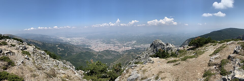

Manisa sits on the Gediz plain about 40 km northeast of İzmir, with Mount Spil rising 1,513 m directly behind it. The old town climbs the mountain's lower slopes; everything built since spreads north across the plain. The city is an Ottoman provincial capital rather than a resort. Süleyman the Magnificent governed here as a prince, and the mosques his family endowed are still the reason to come: the Sultan Mosque of 1522, the Muradiye of 1586 by Mimar Sinan, and the museum that occupies the Muradiye's medrese. Above them the national park holds the Weeping Rock of Niobe and an eight-metre Anatolian relief cut into the cliff along the D250.
Practical information
Practical information
- Language spoken
- Turkish
- English is understood in tourist districts and rarely outside them
- Dialling code
- +90 236
- Manisa landlines; drop the leading 0 of 0236 when calling from abroad
- Currency
- Turkish lira (₺, TRY)
- Cards accepted almost everywhere; markets prefer cash
- Emergency number
- 112
- One number for ambulance, fire and police
- Plug type
- Type C and F · 230 V
- Standard European two-pin
- Tap water
- Not recorded
- No verified national source in the dataset
Planning a visit
- Seasonal closure recorded
- The current month
- Suggested stay
- 1–2 days
- Getting around
- On foot, plus a car for the mountain
- January: seasonal closure recorded
- February: seasonal closure recorded
- March: seasonal closure recorded
- April: seasonal closure recorded
- May: seasonal closure recorded
- June: seasonal closure recorded
- July: seasonal closure recorded
- August: seasonal closure recorded — this month
- September: seasonal closure recorded
- October: seasonal closure recorded
- November: seasonal closure recorded
- December: seasonal closure recorded
Top things to see
Ranked by importance — sitelinks, pageviews and heritage status, not editor preference.
Filter the list
0 places match
0 places match
Category
Typical visit duration
Nothing in Manisa matches all of those filters
The list is built from real place data, so an empty result means the combination genuinely has no match — not that the page failed. Loosen one filter and the ranking returns.
Clear all filtersSource: OpenStreetMap contributors, Wikidata ·
Where to base yourself
District boundaries come from OSM administrative relations, so a district page holds exactly the places inside it — plus, for the islands and the coast, the nearest district by proximity.
-
Şehzadeler
- Places
- 87
- Across the district
- 9 hr 24 min
-
Akhisar
- Places
- 75
- Across the district
- 12 hr 13 min
-
Salihli
- Places
- 52
- Across the district
- 11 hr 27 min
-
Yunusemre
- Places
- 85
- Across the district
- 9 hr 17 min
-
Alaşehir
- Places
- 45
- Across the district
- 9 hr 48 min
-
Sarıgöl
- Places
- 39
- Across the district
- 6 hr 56 min
-
Kula
- Places
- 26
- Across the district
- 8 hr 43 min
-
Gördes
- Places
- 23
- Across the district
- 11 hr 29 min
-
Selendi
- Places
- 22
- Across the district
- 8 hr 55 min
-
Demirci
- Places
- 19
- Across the district
- 9 hr 28 min
-
Turgutlu
- Places
- 24
- Across the district
- 7 hr 54 min
-
Gölmarmara
- Places
- 15
- Across the district
- 5 hr 43 min
-
Soma
- Places
- 14
- Across the district
- 7 hr 47 min
-
Ahmetli
- Places
- 16
- Across the district
- 4 hr 34 min
-
Saruhanlı
- Places
- 17
- Across the district
- 11 hr 8 min
-
Kırkağaç
- Places
- 12
- Across the district
- 8 hr 51 min
-
Köprübaşı
- Places
- 5
- Across the district
- 7 hr 24 min
How the city is laid out
Manisa reads as two strips: the historic quarter on the slope, and the modern city on the plain below it. The two central districts follow that split — Şehzadeler holds the Ottoman core, Yunusemre the newer development and the Celal Bayar University campus.
Everything a visitor comes for is in Şehzadeler, and it is walkable. The Sultan Mosque, the Muradiye and the museum stand within a few hundred metres of each other on the slope, and the bazaar streets run downhill from them. The hill attractions begin roughly 1 km south of the centre, where the streets give out and the national park starts.
North of that line the city is a working Aegean provincial capital: apartment blocks, the university, industry on the Gediz plain. It is not hostile to visitors, it simply has nothing for them. Plan on foot in Şehzadeler and on wheels for anything above or beyond it.
Checked 2026-08-23
Getting around
Manisa is a walking city in the part that matters, and a driving one everywhere else.
The central monuments sit within a few hundred metres of each other on the slope, so the Ottoman core needs no transport at all. Town buses run the main streets for the rest of the city. Mount Spil National Park, the Weeping Rock and the Cybele relief are outside walking range — the relief is carved into the cliff along the D250 — and a car or a taxi is the practical way to reach them.
Arriving is easy from İzmir. Four trains a day leave İzmir Basmane and take about 90 minutes; local buses cover the same 40 km in about 35 minutes on the six-lane highway. Buses running between İstanbul and İzmir call at Manisa, hourly or better, and take about six and a half hours from İstanbul. The nearest airport is İzmir Adnan Menderes, roughly 65 km away.
Checked 2026-08-23
Common questions
How many days does Manisa need?
One full day covers the Ottoman core in Şehzadeler on foot — the Sultan Mosque, the Muradiye and the museum stand within a few hundred metres of each other. A second day is worth it only if you are going up Mount Spil or out to the Cybele relief, both of which need a car.
When is the Mesir Macunu Festival?
Every year from 21 to 24 March, at the Sultan Mosque. The paste is prepared from 41 spices and herbs, wrapped in paper, and thrown from the minaret and domes to the crowd below. UNESCO inscribed the festival on its Representative List of the Intangible Cultural Heritage of Humanity in 2012.
How do I get to Manisa from İzmir?
Four trains a day leave İzmir Basmane and take about 90 minutes. Local buses cover the same 40 km in about 35 minutes on the six-lane highway. İzmir Adnan Menderes is the nearest airport, roughly 65 km away.
What is Mount Spil and can I get up it?
Mount Spil — Mount Sipylus — is the 1,513 m mountain immediately south of the city, and its national park is the reason most Turkish visitors come. It holds forest, wild horses and hiking routes, along with the Weeping Rock associated with the legend of Niobe. The hill attractions start about 1 km south of the centre and a car or taxi is the practical way up.
Is Manisa a day trip from İzmir or a place to stay?
It works as a day trip: 90 minutes by train each way leaves a full day for the Ottoman core. Stay overnight if you want Mount Spil as well, or if you are here in the last week of March for the Mesir festival, when the city fills.
What is the Cybele relief?
An eight-metre figure of an Anatolian mother goddess cut into a cliff face along the D250, several kilometres east of the city. It is Hittite work and predates everything Ottoman in Manisa by well over two thousand years.
Turn this list into a plan
Set your days, your pace and the hours you actually want to be out. The planner works around closing days and travel time, and leaves room to eat.