徒歩272分
シウラ・グランデ
- 必見
- 展望スポット
言語 · 11件公開中
自然スポット · リマ
Laguna Lauricocha
この場所は水域です。
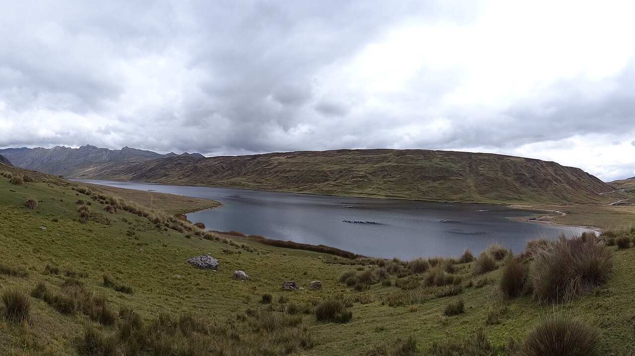
Laguna Lauricocha, known in English as Lauricocha Lake, is a high-altitude body of water in the Peruvian Andes. It lies within the Lauricocha Province of Huánuco Region, not Lima itself, though often referenced in broader Peruvian travel contexts. The lake sits in the Cordillera Huayhuash area, part of the larger Andean watershed. Its remote mountain setting makes it significant for trekkers and those studying Andean geography. A flexible plan lets travellers connect Lauricocha Lake with nearby ranked stops without inventing practical details that the available source pointers do not confirm.
2026-08-28 を確認しました
The lake environment comprises glacial waters surrounded by rugged peaks and puna grassland ecosystems. Archaeological evidence suggests pre-Columbian human presence in the broader Lauricocha area. The region contains varied high-altitude flora and fauna adapted to extreme conditions. No permanent facilities or visitor infrastructure are recorded at the immediate lakeshore. The surrounding terrain demands self-sufficient exploration with appropriate mountaineering or trekking equipment. A flexible plan lets travellers connect Lauricocha Lake with nearby ranked stops without inventing practical details that the available source pointers do not confirm.
2026-08-28 を確認しました
Visiting Laguna Lauricocha requires multi-day commitment from any practical starting point. The approach from Huaraz or similar regional centers involves lengthy road transit plus trekking. Most visitors integrate the lake into extended Cordillera Huayhuash or Cordillera Raura circuit treks lasting five to twelve days. Day-trip access is not feasible. Adequate acclimatization to elevations above 4,000 meters is essential before attempting the approach. Lauricocha Lake belongs in this actual displayed route because it remains one of the city's highest-ranked published stops. The useful visit keeps attention on the place itself and current conditions on arrival.
2026-08-28 を確認しました
The dry season from May to September typically offers more stable conditions for Andean trekking, though weather remains unpredictable at altitude. Rainy season months present increased landslide and river-crossing hazards. Visitors must verify current conditions through local guides or regional authorities before planning. Snowfall can occur year-round at this elevation. Check the operator's own site for the travel date before relying on a schedule or fare.
2026-08-28 を確認しました
No formal entry fee structure for Laguna Lauricocha itself is documented in available sources. Permits may be required for trekking within broader protected areas or community lands. Visitors should expect costs for transportation, guides, pack animals, and camping equipment. Community fees sometimes apply in rural Andean regions; negotiate respectfully with local authorities. Lauricocha Lake belongs in this actual displayed route because it remains one of the city's highest-ranked published stops. The useful visit keeps attention on the place itself and current conditions on arrival. Check the operator's own site for the travel date before relying on a schedule or fare.
2026-08-28 を確認しました
Lima serves as the international gateway, with onward travel to Huaraz or smaller regional centers required. Bus transport from Lima to Huaraz takes approximately eight hours. From Huaraz, additional ground transport and trekking access Laguna Lauricocha via routes through Pachacoto or alternative trailheads. Four-wheel-drive vehicles may reach closer points depending on road conditions. Local guide services strongly recommended for route-finding. Check the operator's own site for the travel date before relying on a schedule or fare.
2026-08-28 を確認しました
Altitude sickness poses serious risk; symptoms include headache, nausea, and disorientation. Weather changes rapidly with potential for hypothermia. Unmarked trails and river crossings present navigation hazards. Limited rescue infrastructure exists in remote areas. Water purification essential. Notify regional authorities of trekking plans. Travel insurance covering high-altitude evacuation advisable. Solo travel inadvisable without extensive Andean experience and satellite communication capability. A flexible plan lets travellers connect Lauricocha Lake with nearby ranked stops without inventing practical details that the available source pointers do not confirm.
2026-08-28 を確認しました
Dawn and dusk offer optimal light on surrounding peaks reflected in still waters. Wide-angle lenses capture the lake's scale against mountain backdrops. Weather windows may be brief; protect equipment from moisture and dust. Tripod useful for low-light conditions. Respect any community restrictions on photography of people or sacred sites. Battery performance degrades in cold; carry spares close to body heat. Lauricocha Lake belongs in this actual displayed route because it remains one of the city's highest-ranked published stops. The useful visit keeps attention on the place itself and current conditions on arrival.
2026-08-28 を確認しました
No. Despite the query specifying Lima, Laguna Lauricocha is located in Huánuco Region's Lauricocha Province, within the central Peruvian Andes. Lima is the international entry point but requires substantial overland travel to reach the lake.
Not recorded in supplied sources. The lake sits in high Andean terrain requiring acclimatization, but precise elevation requires verification from authoritative geographic surveys.
Not recorded. Visitors should assume no infrastructure and practice Leave No Trace principles with fully self-sufficient camping equipment.
While not legally mandated in available sources, hiring a local guide is strongly advisable for safety, route-finding, and community relations in this remote terrain.
Not recorded. Glacial-fed high-altitude lakes are typically extremely cold, making swimming inadvisable without specific local knowledge of safe conditions.
Formal rescue infrastructure is limited to nonexistent in this remote region. Self-rescue capability and appropriate emergency planning are essential responsibilities of visitors.
インタラクティブマップを読み込んでいます…
インタラクティブマップを読み込めませんでした。
最終更新日:
情報源: OpenStreetMap コントリビューター, Wikidata ·