Luogo naturale · Toronto
High Park
Fotografia

- Oggi
- Orari non registrati
- Durata della visita
- 1 ora
- Accessibilità
- Non registrato
- Prezzo
- Non registrato
- Posizione
- Da non perdere · Sito del patrimonio
- Rango
- Classifica 18 di 5,225
Informazioni su High Park
High Park is Toronto's largest central public park, situated in the city's west end. The municipal park encompasses a significant natural area including oak savannah, woodlands, and waterfront along Grenadier Pond. Established through a land bequest in 1873, it serves as a major recreational and ecological resource within Canada's largest city. The park balances maintained landscapes with designated natural preservation zones, offering visitors access to diverse habitats uncommon in dense urban environments. Its scale and central location make it a distinctive metropolitan parkland.
Controllato 2026-08-26
Cosa c'è dentro
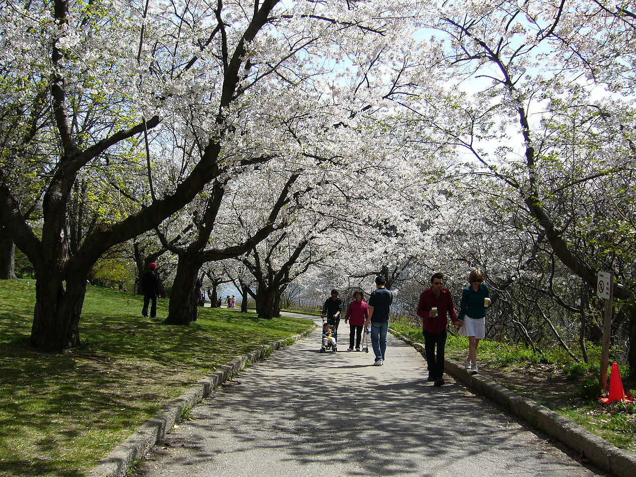
The park contains extensive trail networks through natural and landscaped areas, seasonal cherry blossom trees, formal gardens, and a small zoo operation. Grenadier Pond provides water features and wildlife viewing opportunities. Recreational facilities include sports fields, a swimming pool, and picnic areas. The oak savannah remnant represents a rare ecosystem type. A restaurant and educational programming occur at designated buildings. The zoo houses domestic and native animal species. Naturalized areas contrast with maintained lawns and garden plantings throughout the grounds. High Park also earns time in a toronto itinerary because Toronto's largest central park, valued for trails, cherry blossoms, gardens, and the zoo; no production Toronto POI exists for exact matching. Its value becomes clearer when the stop is compared with the surrounding streets and the other ranked places nearby.
Controllato 2026-08-26

_Stone_Bridge_(9564953669).jpg)
Quanto tempo dedicare
Visitor duration varies considerably by interest and activity selection. Casual walking through central areas may occupy one to two hours. Extended exploration of trail networks, garden areas, and waterfront paths can extend visits to half a day. The zoo, seasonal flower viewing, or organized sports add time. Local residents frequently make repeated shorter visits rather than single extended stays. The park's scale permits both brief stops and full-day engagement depending on personal pacing, weather conditions, and specific destination points within the grounds.
Controllato 2026-08-26

.jpg)
Stagione e folla
Seasonal variation significantly affects visitor experience. Spring cherry blossom flowering draws substantial crowds during peak bloom periods, typically in April or May depending on weather patterns. Summer offers full facility operation and vegetation display. Autumn foliage provides visual interest. Winter conditions limit some access and activities. Operator-confirmed hours are Not recorded pending review. Visitors should consult current municipal information before planning, as seasonal programming, facility availability, and access conditions change throughout the year without guaranteed advance notice of specific operational status.
Controllato 2026-08-26
Biglietti
High Park operates as municipal public parkland with general ground access typically unrestricted during standard hours. Specific facilities within the park may have separate access conditions. The zoo has historically operated without admission charge, though donation requests may apply. Operator-confirmed prices are Not recorded pending review. Visitors should verify current status for any facility-specific requirements, special event admissions, or parking fees that may apply. Municipal budget decisions can alter historical access patterns. Direct confirmation with Toronto Parks, Forestry and Recreation division is advisable before visit planning.
Controllato 2026-08-26
.jpg)
Come arrivare
The park is accessible via Toronto's public transit network, with subway stations located at eastern and northern boundaries. High Park Station on the Bloor-Danforth line provides direct pedestrian access. Streetcar and bus routes serve perimeter streets. Vehicle access exists via multiple entrance points with parking areas, though availability fluctuates with demand and seasonal patterns. Cycling routes connect to the park network. The surrounding residential neighborhood has traffic and parking restrictions affecting visitor vehicles. Walking access is available from adjacent communities throughout the park's extended boundary.
Controllato 2026-08-26

.jpg)
A cosa prestare attenzione
Natural areas include uneven terrain, steep slopes, and trail conditions variable with weather. Ice on paths and pond edges presents winter hazards. Tick presence in naturalized zones requires appropriate precautions during warmer months. Wildlife encounters occur regularly; visitors should maintain distance from all animals. Swimming outside designated areas is hazardous. Bicycle and pedestrian traffic mixing requires awareness. After-hours park use lacks facility support and lighting. Weather changes affect open-area safety. Visitors should carry water, wear appropriate footwear, and inform others of intended routes when exploring extensive trail networks.
Controllato 2026-08-26

.jpg)
Fotografia
The park offers diverse photographic subjects including landscape vistas, floral displays, wildlife, and architectural elements. Cherry blossom season creates concentrated photography activity with attendant crowd management considerations. Natural light varies significantly across seasons and times of day. Morning and evening periods provide favorable conditions for Grenadier Pond reflections and woodland scenes. Tripod use in high-traffic areas may inconvenience other visitors. Commercial photography may require permit arrangements through municipal channels. Respect for wildlife and other visitors should govern equipment positioning and subject approach in shared public space.
Controllato 2026-08-26
Domande comuni
Is High Park free to enter for High Park in Toronto?
General ground access to High Park as municipal public parkland is typically available without admission charge. Specific facilities or programs within the park may have separate conditions. Current status should be confirmed with Toronto Parks, Forestry and Recreation.
When do the cherry blossoms bloom for High Park in Toronto?
Cherry blossom flowering typically occurs in spring, generally April or May, with exact timing dependent on annual temperature patterns and weather conditions. Peak bloom duration is limited. Visitors should monitor current reports for specific seasonal timing.
Is there parking available for High Park in Toronto?
Vehicle parking exists at multiple entrance locations, though availability varies with demand, season, and time of day. Street parking in surrounding residential areas has regulatory restrictions. Transit access may reduce parking dependency.
Can I bring my dog to High Park for High Park in Toronto?
Dogs are permitted in designated areas with leash requirements applying in most locations. Specific zones may prohibit dogs or require leash compliance. Visitors should observe posted regulations and clean up after animals.
Is the zoo still operating for High Park in Toronto?
A small zoo operation exists within High Park housing domestic and native species. Historical operation has been without admission charge. Current status and hours should be verified with municipal sources before visiting.
Are bicycles allowed on all trails for High Park in Toronto?
Bicycle access is restricted to designated paths and roads. Natural surface trails and some pedestrian routes prohibit cycling. Visitors should observe trail markings and yield to pedestrians on shared routes.
Dov'è
Caricamento della mappa interattiva…
Impossibile caricare la mappa interattiva.
Nelle vicinanze
Inseriscilo in un piano
Collegamenti esterni
Ultimo aggiornamento:
Fonte: Contributori di OpenStreetMap, Wikidata ·