دليل المدينة · Sweden
Stockholm
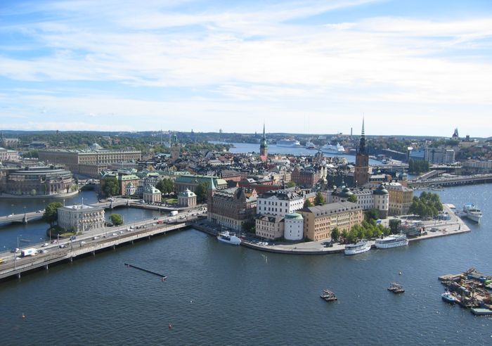

Stockholm spreads across islands joined by bridges, ferries and rail, but its central visitor districts form a manageable chain. Gamla Stan, Norrmalm, Djurgården, Östermalm and Södermalm each reward a separate walking block. Public transport closes the gaps, while boats are part of the useful network rather than only sightseeing. Plan by island and district so repeated water crossings do not consume the day.
معلومات عملية
معلومات عملية
- اللغة المحكية
- السويدية
- التوجه العملي الوطني؛ قد تُستخدم أيضًا اللغات الإقليمية والأقليات
- رمز الاتصال
- +46
- رمز الاتصال الدولي؛ لا تزال تطبق بادئات المنطقة المحلية والجوال
- العملة
- الكرونة السويدية (SEK)
- استخدم العملة المحلية الرسمية؛ يختلف قبول البطاقة حسب المكان
- رقم الطوارئ
- 112
- استخدم فقط في حالات الطوارئ؛ قد يستخدم المساعدة السياحية رقمًا منفصلًا
- نوع القابس
- النوع C و F · 230 V
- تحقق من أن الشواحن تدعم الجهد المسجل قبل استخدام محول
- مياه الصنبور
- آمن من الشبكة الرئيسية
- تخضع مياه الشرب البلدية لضوابط السلامة الغذائية السويدية
حوّل هذه القائمة إلى خطة
حدّد أيامك، وتيرتك، والساعات التي تريد فعلاً الخروج فيها. يعمل المخطّط مع أيام الإغلاق ووقت السفر، ويترك متسعاً للأكل.
تخطيط زيارة
- مدة الإقامة المقترحة
- 3-4 days
- التنقل
- Metro, rail, tram, bus, boat and walking
- أفضل وقت
- وقت جيد
- مناسب مع اعتبارات
- ظروف صعبة
أهم المعالم السياحية
مرتبة حسب الأهمية — الروابط الموقعية، وعدد المشاهدات، وحالة التراث، وليس تفضيل المحرر.
تصفية القائمة
0 مكان مطابق
0 مكان مطابق
الفئة
مدة الزيارة المعتادة
الاهتمامات
لا يوجد في Stockholm ما يطابق كل تلك الفلاتر
تُبنى القائمة من بيانات أماكن حقيقية، لذا يعني النتيجة الفارغة أن التركيبة ليس لها تطابق فعلي — وليس أن الصفحة فشلت. أرخِ أحد الفلاتر ويعود التصنيف.
المصدر: مساهمو OpenStreetMap, Wikidata ·
تخطيط المدينة
Gamla Stan is the historic hinge between the northern and southern halves of central Stockholm. Norrmalm, the main commercial and transport centre, lies immediately north; Östermalm and museum-rich Djurgården continue east. Södermalm rises south of the old town, while Kungsholmen and Vasastan extend west and northwest. The official visitor guide identifies seven central districts with distinct characters. Combine adjacent districts on foot, and treat the archipelago or distant suburbs as separate outings.
تم التحقق 2026-08-26
التنقل
Use the SL network of metro, commuter rail, tram, bus and selected local boats for moves between districts. The centre is compact enough for substantial walking, but water and rail lines determine the quickest route more than straight-line distance. Use one valid SL ticket product consistently and check the official journey planner before island connections. Djurgården can be reached by tram or ferry, while outer archipelago travel requires separate route planning.
تم التحقق 2026-08-26
الأسئلة الشائعة
How many days does Stockholm need?
Three to four days suit a first visit. Use the first days for Gamla Stan, Norrmalm, Djurgården and Södermalm, then reserve additional time for a longer island or archipelago route.
When is the best time to visit Stockholm?
May through September gives the most useful daylight for walking between districts and using boat connections. Winter can still work for museums and indoor culture, but outdoor sightseeing time is much shorter.
Is central Stockholm walkable?
Yes, within one district and between several central islands. Bridges, hills and water make some apparently short cross-city routes slower, so use public transport when changing from one side of the centre to another.
Can visitors use boats as public transport?
Yes. Selected local boat services form part of the wider public transport network. Check the SL journey planner and ticket conditions for the specific route rather than assuming every sightseeing or archipelago boat is included.
Which Stockholm districts combine well?
Gamla Stan and Norrmalm combine naturally, while Östermalm and Djurgården make another coherent block. Södermalm deserves its own walking route, especially when viewpoints and evening stops are included.