أثر تاريخي · Cusco
Choquequirao
صورة فوتوغرافية

- اليوم
- ساعات العمل غير مسجلة
- مدة الزيارة
- 45 د
- إمكانية الوصول
- غير مسجّل
- السعر
- غير مسجّل
- المكانة
- مرتفع · موقع التراث
- رتبة
- الرتبة 81 من 2,497
نبذة عن Choquequirao
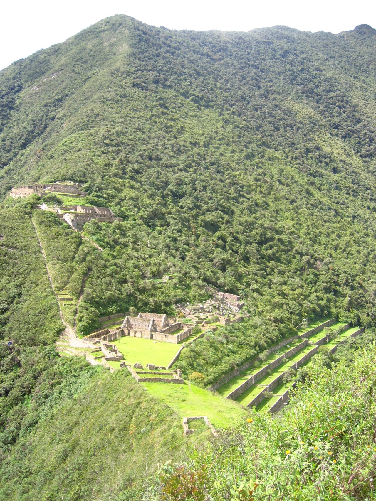
Choquequirao is a remote Inca archaeological site situated in the Vilcabamba mountain range of the Cusco region. Often called the sister city of Machu Picchu, it remains far less visited due to its isolated location. The complex spans a ridge above the Apurímac River canyon. Its construction dates to the late 15th and early 16th centuries during the reign of the Inca Empire. The site served administrative, religious, and residential functions. Extensive terraces cascade down steep slopes. Ongoing archaeological work continues to reveal new sectors. Its inaccessibility has preserved original features absent at more developed destinations.
تم التحقق 2026-08-26
ماذا يوجد بالداخل
The site contains multiple distinct sectors spread across the ridge. Principal areas include ceremonial plazas, residential zones, storehouses, and agricultural terraces. Notable features include the Ushnu ceremonial platform and systems of water channels. Some walls retain original Inca stonework precision. The famous llama terraces display stone figures integrated into terrace walls. Temple complexes and elite residences occupy higher elevations. Lower areas contain more common dwellings and extensive farming infrastructure. The site demonstrates classic Inca urban planning adapted to dramatic topography. Visitors should expect uneven surfaces and significant elevation changes throughout. Not all sectors may be accessible depending on conditions and restoration activity.
تم التحقق 2026-08-26

المدة المقترحة للزيارة
Reaching Choquequirao requires substantial time commitment. The trek from the nearest road access point at Cachora typically spans four days minimum round trip, with two days descending to and ascending from the site. Many travellers extend to five or more days to allow adequate exploration time at the ruins themselves. The hiking involves steep descents into the Apurímac canyon and strenuous climbs back out. Physical fitness and acclimatisation to altitude are essential prerequisites. Day trips are impossible. Visitors must carry camping equipment or arrange mule-supported expeditions. Weather delays can extend itineraries. Proper preparation for remote backcountry conditions is mandatory.
تم التحقق 2026-08-26

.JPG)
الموسم والحشود
The dry season from May to September generally offers more stable conditions for trekking, though mountain weather remains unpredictable year-round. The rainy season from November to March increases trail difficulty and landslide risk significantly. Operator-confirmed hours are Not recorded pending review. Independent verification of current access conditions is essential before planning. Local guides and established trekking operators possess current route information. River crossings may become impassable during heavy rains. Fog and cloud cover can obscure views even during drier months. Early starts help avoid afternoon precipitation patterns. Flexibility in scheduling accommodates weather-related delays inherent to remote mountain environments.
تم التحقق 2026-08-26
التذاكر
Entry to the archaeological zone requires payment of fees, though specific current amounts are Not recorded pending review. Separate charges may apply for camping within designated areas. Budget for guide services, mule or porter support, food, and equipment rental or purchase. Costs accumulate significantly for multi-day remote expeditions compared to accessible sites. No ATM facilities exist near trailheads. Carry sufficient cash in Peruvian soles. Verify whether fees have changed since last published information. Some trek packages bundle site entry with logistical support. Independent travellers must arrange all components separately. Receipts should be retained for checkpoint verification during the approach trek.
تم التحقق 2026-08-26


الوصول إلى هناك
The standard access route begins from Cachora village, approximately four hours by road from Cusco. Public transport options exist though schedules require local confirmation. Private vehicle or arranged transport provides more reliable timing. From Cachora, the trail descends steeply to the Apurímac River before climbing to the site. Alternative routes from Huanipaca exist but see less use. No road reaches Choquequirao itself. All approaches demand substantial walking. Mule trains carry heavier equipment for organised groups. The trail network continues beyond to other Vilcabamba sites for those undertaking extended treks. Self-sufficiency in remote terrain is unavoidable.
تم التحقق 2026-08-26


ما يجب الحذر منه
Altitude affects most visitors, with passes exceeding 3,000 metres. Acclimatise in Cusco before attempting the trek. The canyon environment generates extreme temperature variations between hot days and cold nights. River crossings demand caution, particularly after rainfall. Trail conditions deteriorate during wet periods with mud and erosion. Limited rescue infrastructure exists in this remote zone. Travel insurance covering emergency evacuation is strongly advised. Water purification is necessary as no reliable treated sources exist en route. Sun exposure intensifies at altitude. Physical exhaustion causes most problems; know personal limits. Inform others of intended itinerary and expected return. Mobile phone coverage is minimal or absent throughout.
تم التحقق 2026-08-26


التصوير الفوتوغرافي
The dramatic setting offers exceptional photographic potential when conditions permit. Morning light illuminates eastern-facing structures while afternoon suits western areas. Cloud formations create atmospheric effects but may obscure broader vistas. The steep terrain provides numerous elevated viewpoints. The llama terraces represent distinctive subjects found nowhere else in Inca architecture. Wide-angle lenses accommodate the expansive scale. Extra batteries essential as no charging facilities exist; cold temperatures reduce battery performance. Protect equipment from dust and moisture on the trail. Tripods useful for low-light interiors though weight considerations apply. Respect any restricted zones where photography may be limited due to ongoing archaeological work.
تم التحقق 2026-08-26
الأسئلة الشائعة
How does Choquequirao compare to Machu Picchu for Choquequirao in Cusco?
Choquequirao shares architectural similarities and historical significance but receives far fewer visitors due to remote access requiring multi-day trekking. The site remains less restored and more archaeologically active. Scale and setting are comparable though Choquequirao spreads across a longer ridge. Those seeking solitude and raw archaeological atmosphere may prefer it; those needing comfort and convenience should consider accessibility limitations.
Is a guide necessary for visiting for Choquequirao in Cusco?
While not always formally mandatory, employing a guide is strongly advisable given remote terrain, navigation complexity, and safety considerations. Guides provide local knowledge, arrange mule support, and manage camp logistics. Independent trekking demands thorough preparation and self-sufficiency. Established Cusco-based trekking operators offer organised departures with comprehensive support.
What fitness level is required for Choquequirao in Cusco?
The trek demands solid physical conditioning and prior hiking experience. Daily distances involve significant elevation loss and gain on steep, uneven trails. The canyon descent and subsequent ascent challenge knees and cardiovascular capacity. Altitude adds additional strain. Training beforehand with loaded pack walking on hills is recommended preparation.
Are there facilities at the site for Choquequirao in Cusco?
No permanent lodging, restaurants, or shops exist at Choquequirao. Basic camping areas provide designated tent spaces. All food, water treatment, and shelter equipment must be carried in or transported by arranged support. The nearest services are in Cachora village at the trailhead. Complete self-sufficiency during the trek is essential.
Can the trek be done in wet season for Choquequirao in Cusco?
Possible but inadvisable for most travellers. Rain increases trail hazards, river crossing dangers, and landslide risk. Views become obscured. Muddy conditions slow progress considerably. Some operators suspend departures. Only highly experienced trekkers with appropriate equipment and flexible schedules should consider wet season attempts.
Is there a cable car project that might improve access for Choquequirao in Cusco?
Proposals for cable car installation have circulated for years but implementation remains uncertain. Current access continues exclusively by foot or mule trail. Travellers should not plan visits assuming future infrastructure improvements. Verify latest conditions through current sources rather than anticipating announced projects that may face delays or cancellation.
أين هو
جاري تحميل الخريطة التفاعلية…
تعذر تحميل الخريطة التفاعلية.
قريب
ضعها في خطة
روابط خارجية
آخر تحديث:
المصدر: مساهمو OpenStreetMap, Wikidata ·