徒歩8分
桜田門
- 必見 · 遺産
- 史跡
言語 · 11件公開中
史跡 · 東京都
水準原点
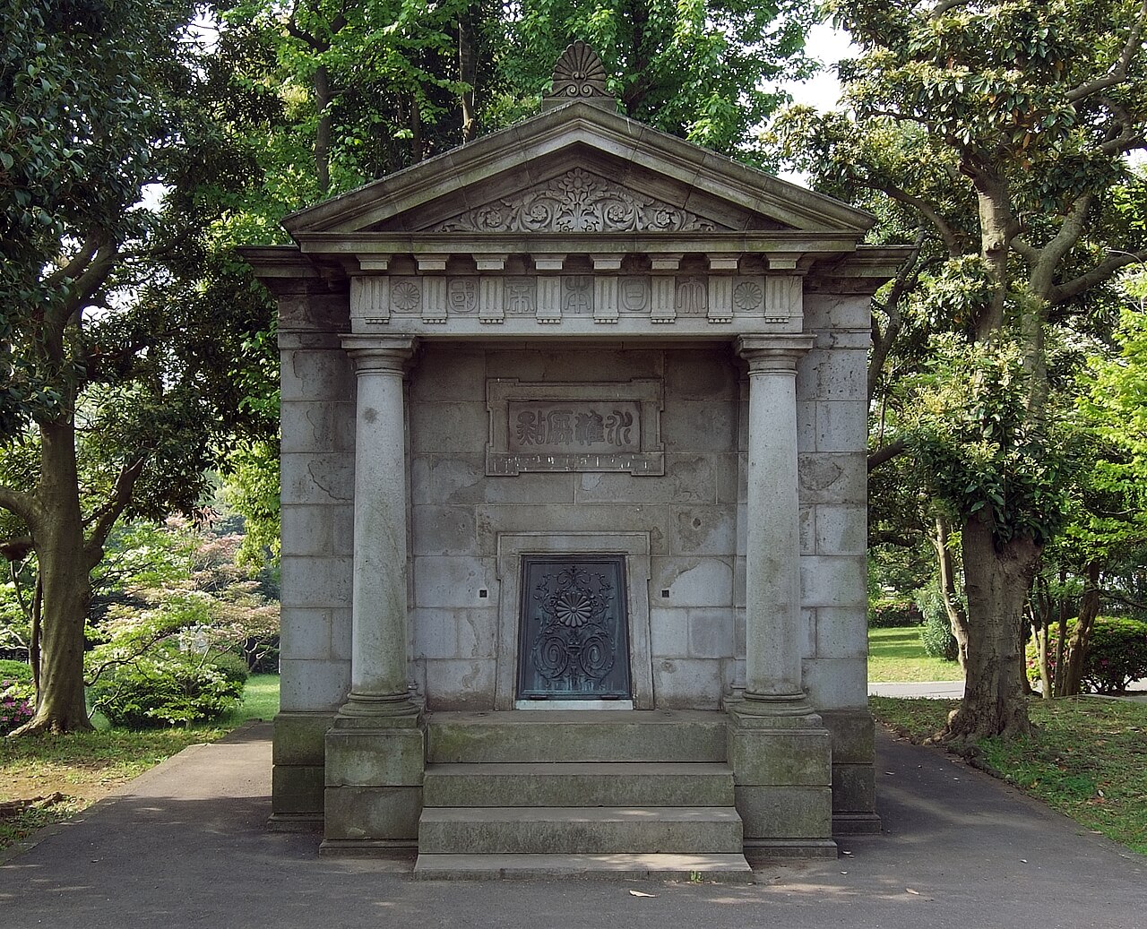
The Japan Vertical Datum, known locally as 水準原点 (Suijun Genten), is a geodetic benchmark serving as Japan's official reference point for measuring elevation above sea level. Established for surveying and cartographic purposes, this scientific monument provides the foundational zero-height standard used in topographic maps, construction projects, and engineering works throughout Japan. The monument represents a critical piece of national infrastructure for spatial measurement, though it is not designed as a conventional tourist attraction. Visitors should understand this is primarily a technical reference point with limited public interpretation facilities.
2026-08-28 を確認しました
The site consists of a physical benchmark monument marking the precise vertical datum point. There are no exhibition halls, visitor centers, or interpretive displays associated with this installation. The monument itself is the sole feature of interest, typically comprising a standardized survey marker or pillar structure. No buildings, museums, or ancillary facilities are present. The surrounding area appears to be standard urban streetscape without dedicated visitor amenities. Those expecting a museum experience will find only the benchmark monument and its immediate setting. Photography of the marker is possible from public thoroughfares.
2026-08-28 を確認しました
A visit to the Japan Vertical Datum requires minimal time commitment. Most visitors will spend between five and fifteen minutes observing and photographing the benchmark monument. There are no queues, guided tours, or interactive elements extending the duration. The experience is essentially a brief stop for those with specific interest in geodesy, surveying history, or benchmark collecting. Combined with nearby attractions in the Kasumigaseki district, the monument can serve as a minor waypoint in a broader itinerary. Dedicated visitors should plan accordingly, treating this as a quick observation rather than a destination in itself.
2026-08-28 を確認しました
The Japan Vertical Datum is an outdoor monument accessible at all hours from public spaces. No gates, doors, or admission controls restrict viewing. The monument offers no weather protection, making clear conditions preferable for photography and comfortable observation. Daylight hours provide optimal visibility of the marker details. No seasonal variations in accessibility apply. Visitors should exercise standard urban awareness regardless of timing. Night visits are physically possible though practical value diminishes without adequate lighting. Morning and afternoon periods likely offer best combination of visibility and surrounding activity. Check the operator's own site for the travel date before relying on a schedule or fare.
2026-08-28 を確認しました
No admission fee applies to viewing the Japan Vertical Datum from public areas. The monument is visible from surrounding streets without entering restricted zones. No ticketing infrastructure, payment systems, or revenue collection mechanisms are present. Visitors incur only personal transportation costs to reach the location. No guided tour services, audio guides, or premium access options are available for purchase. The experience remains entirely free of charge. Budget-conscious travelers may appreciate this as a zero-cost addition to central Tokyo itineraries, though expectations should remain modest given the technical nature of the site. Check the operator's own site for the travel date before relying on a schedule or fare.
2026-08-28 を確認しました
The Japan Vertical Datum is located in Tokyo's Kasumigaseki district, an area well-served by public transportation. Multiple Tokyo Metro stations provide nearby access, including Kasumigaseki Station serving the Marunouchi, Hibiya, and Chiyoda lines. The monument sits within walking distance of these underground stations. Street-level navigation requires attention to specific address location rather than prominent signage. The surrounding government district features regular street patterns but limited distinctive landmarks for orientation. Mobile mapping applications using the OpenStreetMap node reference prove valuable for precise location. Walking from nearby stations involves standard urban distances through commercial and administrative streetscapes.
2026-08-28 を確認しました
Visitors should recognize this is a functioning scientific instrument within an active administrative district, not a recreational facility. Photography is possible from public spaces but should avoid interfering with any maintenance or monitoring activities. The Kasumigaseki area contains numerous government buildings; visitors should remain on public thoroughfares and respect any restricted zones. No visitor services such as restrooms, seating, or refreshments are available at the monument itself. Weather exposure requires appropriate preparation. The monument's modest appearance may disappoint those expecting dramatic presentation. Security presence in the surrounding government district may be noticeable; standard compliant behavior avoids complications.
2026-08-28 を確認しました
Photography of the Japan Vertical Datum benchmark is feasible from surrounding public streets and sidewalks. The monument's scale and setting permit straightforward documentation without specialized equipment. Optimal angles may require brief exploration of adjacent viewpoints. No photography restrictions are evident from public vantage points, though intrusive or prolonged equipment setup might attract attention in this government district. The marker's inscription and technical details reward close-up capture. Lighting conditions vary by time and weather; overcast skies reduce harsh shadows on the monument surface. No dedicated viewing platform or marked photo spot exists. Visitors should remain aware of pedestrian and vehicular traffic while positioning for shots.
2026-08-28 を確認しました
Most general visitors will find limited appeal. The site suits those with specific interest in geodesy, surveying, or benchmark monuments. Others may prefer conventional attractions.
There is no enclosed site to enter. The benchmark is viewable from public streets without crossing boundaries or passing through gates.
No guided tours or interpretive services are associated with this monument. Visitors observe independently without structured programming.
Using mobile maps with the OpenStreetMap node reference or coordinates provides precision. Street addresses and local knowledge offer supplementary navigation assistance.
Specific lighting arrangements are not recorded. Night visibility likely depends on ambient street lighting in the surrounding district.
The Kasumigaseki and adjacent districts contain government buildings, parks, and commercial areas. The Imperial Palace and Hibiya Park lie within reasonable walking distance for extended itineraries.
インタラクティブマップを読み込んでいます…
インタラクティブマップを読み込めませんでした。
最終更新日:
情報源: OpenStreetMap コントリビューター, Wikidata ·